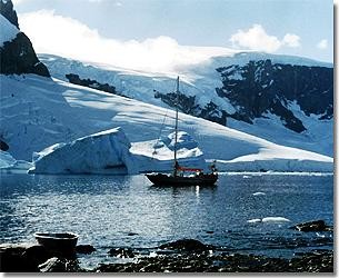
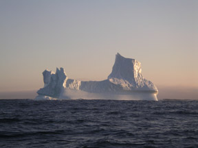
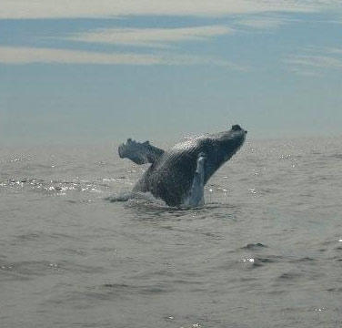
This was the first time we had seen penguins and we spent hours sitting in rookeries watching their raucous behavior. Seals were common, including the ferocious leopard seal, and on two occasions we had humpback whales close by the boat. We got as far south as Mutton Cove at 66.02S, 28 miles short of the Antarctic Circle .Further south there was too much ice. It was February 15 th and we had a long way to go before the end of the southern summer.
The weather was fair on the way back across the Drake Passage, but a front caught us on the last day giving us a real struggle to get to an anchorage behind the islands to the north of Cape Horn. After some R&R at Puerto Williams and Ushuaia, we set out for Buenos Aires, where we planned to leave Taonui for the winter. On March 27 th we were holed up deep inside Caleta Hoppner on Staten Island while a very deep low passed over. It was 950 at the center and 2,500 miles across. The wind howled for four days. After the barometer climbed back to 1003 we left in calm conditions. Another low caught us and this time we were unlucky. While lying ahull to let the storm pass we were caught by a fluke wave and slammed upside down. The mast was broken and Tony was thrown overboard. Coryn scrambled on deck, threw Tony a life ring and hauled him back to the boat. We cut away the mast and motored 200 miles to the Argentinean coast, and eventually shipped Taonui back to Lymington, UK for repair. Not a good end to an exciting trip.
1998 ICELAND
 In the early spring of 1998 we returned to Lymington. Taonui was ready to go with a new, much stronger mast and rigging, new sails, including two roller-furled genoa's on the bow. The damage caused by the knockdown had been fully repaired. To test all the new gear, we decided to spend the summer on a trip around Iceland. We cruised up the Western Isles of Scotland before visiting the Faeroes and then on to Vestmanna on the Southwest coast of Iceland. We found the coast of Iceland rather barren and uninteresting. There are very few anchorages, only man-made fishing harbours. The history is intriguing and the people are warm and friendly, but rolling lava fields with not much greenery are a bit dull. We sailed directly to Stornoway, in the outer Hebrides and were back in Falmouth at the end of August. In the early spring of 1998 we returned to Lymington. Taonui was ready to go with a new, much stronger mast and rigging, new sails, including two roller-furled genoa's on the bow. The damage caused by the knockdown had been fully repaired. To test all the new gear, we decided to spend the summer on a trip around Iceland. We cruised up the Western Isles of Scotland before visiting the Faeroes and then on to Vestmanna on the Southwest coast of Iceland. We found the coast of Iceland rather barren and uninteresting. There are very few anchorages, only man-made fishing harbours. The history is intriguing and the people are warm and friendly, but rolling lava fields with not much greenery are a bit dull. We sailed directly to Stornoway, in the outer Hebrides and were back in Falmouth at the end of August.
1999 SOUTH GEORGIA (Tony)
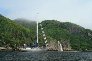
When we were in the Cape Horn area, South Georgia was like a magnet to the east. . . less than a thousand miles away. An isolated wilderness with spectacular mountain scenery and teeming with wildlife in the summer months, it is seldom visited by yachts. Our plan was for Tony to sail single handed to the Falklands and then the two of us would sail the 900 miles to South Georgia, spend 2 months there and then run to Cape Town 2,800 miles to the NE.
I left Falmouth on September 14 th and stopped in the Canaries for a month to let the seasons progress and carry out some needed varnishing and TLC on Taonui. I left the Canaries at the end of October and after a few brief stops along the way, reached Stanley in the Falklands on the evening of December 16 th. Coryn was waiting on the dock, but I couldn't get ashore because of the howling west wind that frequently blows down the harbour. We spent Christmas in Stanley and left on New Year's Day for South Georgia. South Georgia was everything we had hoped for. It is only 100 miles long and, with one exception, the harbours are only on the east coast. There were a few administrative people in Grytviken along with 15 army personnel (now replaced by scientists).
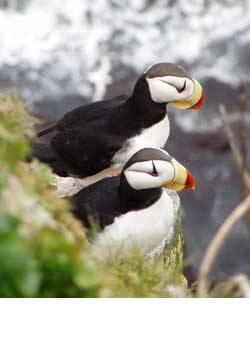
| Aside from them and one other yacht, Wanderer III, we had South Georgia to ourselves. We had a great time tromping over the foothills and lower snowfields. Hours were spent watching the wildlife; fur seals, elephant seals, and penguins. . . millions of penguins, and the five species of albatross that nest on South Georgia, including the majestic wandering albatross. Exploring the ruins of the whaling stations was interesting but it was sad and sobering to think about the over 180,000 whales that were killed in the waters around South Georgia, before the killing moved to offshore factory ships. |
|
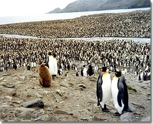
King Penguins, St. Andrews Bay
 |
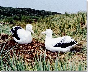
Nesting Wandering Albatross
 |
|
South Georgia is a tough place to sail. The west winds falling down the mountains can reach 40 - 60 knots seemingly out of the blue. Wherever possible we were tied to the shore as well as being held by tandem anchors. |
Our last anchorage was in tiny Albatross Lagoon in Coopers Bay at the south end of the island; here we had 7 days of glorious weather to walk the hills and explore the penguin rookeries. Young fur seals spent hours playing under and over our lines, while the bulls strutted their stuff on the beach. Huge male elephant seals were coming ashore to molt and the penguin chicks were losing their baby feathers. It was a little bit of Paradise.
However, the season was getting on and we had a rough sail ahead of us, crossing the Roaring Forties starting at 53'S, all the way to Cape Town at 35'S. We kept south of 40'S until we were 5 days from Cape Town. This gave us a fast, but sometimes bouncy trip. The trip took 20 days, including 16 hours lying to the drogue, while a bad front went by.
We left Taonui at the Gordon's Bay YC, 50 miles east of Cape Town while we did some tourist trips. We drove along the Garden Route on the south coast, and then flew to Johannesburg, where Coryn's cousin took us for a week's camping in the Kruger Park. We then went to Victoria Falls and made a week's canoe trip (with guides) down the Zambezi River. The hippos and crocodiles were a lot scarier than the big waves of the southern ocean.
1999 - 2000 THE SOUTHERN OCEAN (Tony)
At the end of April we flew back to Victoria and I went on to Australia, as my father was very ill. We had originally planned that I would sail single-handed from Cape Town to Halifax and we would then cruise the coast of Labrador. That summer we concocted the idea that I would complete a circumnavigation by sailing solo back to Falmouth by way of all the southern capes. I flew to Cape Town at the end of September and left a month later for Hobart. I headed south to get into the westerlies and then stayed between 42'S and 44'S it took 41 days to cover the 6,100 miles to Hobart.
Taonui was in her element. The poled out twin head sails pulled her along with a comfortable motion that was easy on the self-steering. Coryn flew down a week after I arrived in Hobart and we spent 6 weeks exploring Tasmania by car and boat and flying up to Sydney to visit my family. On New Year's Eve 1999, we were anchored in the perfect horseshoe of Wineglass Bay in SE Tasmania. The sky was full of stars and a big moon. We toasted the Millennium with some excellent Aussie wine.
On the next leg I passed south of New Zealand and ran along 45'S for 3 weeks before dipping down to 56 S for the last 1,800 miles to Cape Horn. After a 4 day stop in the Falklands for food, water and a clean up, I caught a favorable wind and cracked off 531 miles in the first 3 days. A great start up the Atlantic. |
|
 |
After that the wind was mostly on the nose. Of the 55 days it took to cover the 6,500 miles to the Azores, 29 days were close hauled, Taonui's least favourite point of sailing. The 7 day sail from the Azores back to Falmouth was a glorious broad reach giving an average daily run of 170 miles. A lovely finish to a very satisfying sail. The trip, Falmouth to Falmouth, including going to South Georgia was 30,750 miles covered in 229 days sailing.
2001 SPITSBERGEN
Coryn has always wanted to visit the Lofoten Islands off Northern Norway. In that Spitsbergen is only 400 odd miles north of Norway, this seemed like a good objective for the summer. We left Lymington in mid-April and headed north up the Irish Sea. Friends from Victoria joined us for the passage through the Western Isles of Scotland, which were as beautiful as ever. It's a superb cruising area with many sheltered anchorages and wonderful scenery.
We reached the Shetland Islands by mid-May and then headed for the Lofotens 600 miles to the NE. The mountain scenery and fishing harbours of Northern Norway and the Lofotens are the stuff of picture books, as long as it isn't raining.
We were lucky. It was mid-June and north of the Arctic Circle there was 24 hour sunshine.
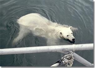
On June 20 th we set out for Hornsund, a large indentation 25 miles up the west coast of Spitsbergen. In summer the tail end of the Gulfstream keeps the west coast of Spitsbergen relatively free of ice. We had to push through about 20 miles of broken pack ice to get to Hornsund and after that, ice was rarely a problem. At anchor in one of the inner bays of Hornsund we were visited by a curious polar bear that got quite a surprise when he slapped the side of our metal boat. |
|
 |
We spent 6 weeks gunkholing up the west and northwest coast. The island is deeply indented and there are plenty of anchorages. The weather was kind most of the time with very light wind, if any, as we were well within the Arctic high-pressure area. The bird life is prolific as it is a major breeding area for a number of northern sea birds. . .murres, auks and the like. At Moffen Island (80N), we were only 600 miles from the North Pole. Here there is a small herd of walrus, all that is left of the thousands that previously lived on Spitsbergen. Three of them swam around our boat giving us an unexpected close-up look at these great beasts.
On the way back to Norway a low had crossed south of us and then deepened by 10 millibars and become stationary. The resultant Force 9 -10 wind was driving us onto the rather dangerous north coast. We spent 24 hours hanging on the end of the drogue and stayed about 100 miles offshore until the low finally moved on. We retraced our route down the Norwegian Sea to Lerwick and then through the western Isles to arrive back in Lymington at the end of August. It was a long way to go for a summer holiday, 5,300 miles, but well worth it.
2002 ATLANTIC CROSSING
In April 2002 we flew over to the UK to get Taonui ready for sea again. Berthons yard in Lymington had completed a number of improvements and repairs, and by the end of May Taonui was once again in the water. We arrived in Falmouth in early June after a leisurely sail along the south coast of England. Here we laid on food for the trans-Atlantic crossing plus 100 tins of Marks and Spencer's tinned meals for use on the around-the-world trip.
The prevailing westerly winds over the North Atlantic vary from NW to W to SW, depending on where you are relative to the shifting position of the North Atlantic High, and the passage of lows that develop over Newfoundland and the Atlantic seaboard and then track east to northern Europe. I had arranged for an old sailing friend, Chris Barry, to join me for the trip across the Atlantic, as Coryn didn't relish the thought of 4 weeks sailing upwind
. life on the slant. We left Falmouth on June 17 th and spent the next 6 days beating our way southwest in strengthening winds that reached 30 - 35 knots, before shifting to the south and going light. The Atlantic High was moving north and by the 7th day the barometer had risen to 1038, and the wind died to a SW breeze. We motored for 12 hours across the high point of the High and picked up southerly winds on the other side.
Then we were lucky. The High started to expand and move back to its normal position in the middle of the Atlantic, centered to the west of the Azores. We stayed on the western side of the high and for the next 14 days we had SSW winds Force 3 - 4. We were slightly freed-off on port tack making our way W of SW on essentially a rhumb line course to Boston. Every day Chris checked the weather fax and declared we had at least one more day of good winds. And so it held until we were 300 miles from Gloucester, our destination 80 odd miles north of Boston. For the next 4 days the wind shifted 5 - 10 degrees either side of W of NW and was right on the nose, no matter which way we played the wind shifts. Tacking upwind in the open ocean in Force 5 - 6 winds is not much fun.
We arrived at Gloucester in the late afternoon of July 13 th, having sailed 3,126 miles in 26 days, all of it closehauled. Taonui was hauled at Browns Yard, awaiting pick-up by truck in early August for her "land sail" to Anacortes, 100 miles north of Seattle. After endless delays in the trucking, Taonui arrived in Anacortes on August 20, leaving only 5 weeks to get her together again and ready for the attempt at a solo non-stop circumnavigation.
2002 - 2003 VICTORIA - VICTORIA NON-STOP SOLO
To read an account of this trip please click here
2003 - 2004 ALEUTIAN ISLANDS AND THE BERING SEA
In the summer of 2003 we sailed Taonui north to Alaska. After spending two weeks re-visiting the wonderful cruising grounds in Prince William Sound, we moved on to Seward and left Taonui there on the hard for the winter. In late May 2004 we set off again, heading west to explore the deeply indented Kenai Peninsular with its spectacular tide-water glaciers flowing down from the mountains; and then on down the Alaskan Peninsular and Aleutian Islands to Dutch Harbor. The anchorages on this coast are typically open and windswept. Climatically the Alaskan Peninsular is above the tree line, so once ashore there is great hiking to be had over the grass covered hills. The valleys and hills create some strange wind circulation patterns including 35 to 50 knot williwaws that try to blow one out of the anchorage. It's imperative to have good ground tackle in these waters. We had some great beachcombing along the seldom-visited bays, but were always on the look out for Grizzly Bears especially when we came across fresh prints in the sand. Bears are great scavengers and we often saw them wandering the beaches looking for food.
For the most part Dutch Harbor is an industrial city, totally dedicated to processing fish harvested in the Bering Sea. The Russians established a major trading post there in 1772 and throughout Dutch Harbor there are reminders of the Russian history including a cruciform church built in 1825, and many old Russian grave markers at a nearby cemetery.
From Dutch Harbour we headed 200 miles north into the Bering Sea to the Pribilof Islands. The Russians came here in 1790 to harvest fur seals. They brought natives from the Aleutians to do the dirty work and of course built a traditional Russian Church. When the United States took over in 1867 they continued the seal harvest and within 20 years the government tax on sealskins had recouped the entire $7.2 million they had paid Russia for all of Alaska. The fur seals still return to the beaches on the Pribilofs each spring. Intensive harvesting in the early 1800's almost wiped them out, but with the cessation of sealing in 1984, the stocks recovered. However, their numbers are again falling, this time due to declining availability of food due to over-fishing by massive industrial-sized trawlers.
Leaving St. Pauls Island, we sailed 45 miles south east to see the famous bird cliffs on St. George Island, which are the breeding site for millions of seabirds. |
|
 |
The Russians established the small town on St. George as a base for the harvesting of fur seals. Many of the Islanders have Russian names and still adhere to the Russian Orthodox religion .Their church is in good condition, but with the cessation of sealing there is no source of employment. The population is declining and there is talk of abandoning the Island.
Deliberately there are no roads to the bird cliffs, which are only accessible via a long walk through a carpet of wild flowers. The cliffs are 100 to 300 feet high and the sedimentary rock formations provide ideal nesting platforms.
Over 200 species of birds have been sighted on St. George Island. The most common are the Murres, also known as Guillemots, and Black-legged Kittiwakes, which are found across most of the oceans of the Northern Hemisphere. Other common birds are: Red-legged Kittiwakes, found only in the Aleutian Islands and the Bering Sea, Horned Puffins and Tufted Puffins, Red-faced Shags and all 6 Northern Pacific Auklets. | |
 |
From St. George we had an easy 500-mile sail north to Nome, the site of one of the world's great gold rushes. Nome is at 64 degrees 50 minutes north, only 160 miles from Russia. It is so shallow along this coast that the ships bringing the gold prospectors had to anchor a mile offshore. Today there is a small harbour reached through a dredged channel with a sharp 90-degree bend to try to cut down on the wave action. The discovery of gold on the beaches around Nome triggered a stampede in 1900 that brought 20,000 fortune seekers to this remote place. After the beaches had been dug over, the gold seekers turned to dredging the rivers and low lying land.
|
|
 |
The trip back south from Nome was a real upwind struggle. The wind stayed on the nose the entire way and culminated in a southerly gale that forced us to seek shelter in the lee of St. George Island. We had hoped to go ashore but it was just too windy. A day later we sailed the remaining 200 miles south to the Aleutian Islands to anchor on the north side of Unmak Island where there was once a thriving sheep ranch. We had hoped to stay longer in the Aleutians, but a northerly gale forced us out of the anchorage and with no safe alternative we set off home to Victoria. It was a hard beat to get back up Unmak Island to the pass between it and the western end of Unalaska Island. Contrary tide in the pass and a 30-knot headwind gave us a rough time, but once free, we took off in a fine SW wind for the 1,800 mile trip back to Victoria. Our last sight of the Aleutians was snow-covered volcanoes, a fine finish to a visit to these remote Islands.
Two days later the wind went back into the west and stayed there for the rest of the trip. Albert, our faithful wind vane did all the steering as we roared along on a broad reach or wing and wing, logging 160-mile days. Taonui just loves this kind of down wind sailing, lots of steady wind, following seas and a wide ocean to cross. After 12 days at sea we sailed down the Straits of Juan de Fuca and on past Race Rocks Lighthouse to Victoria.
2005 NOVA SCOTIA
In late May we trucked Taonui from Anacortes, Washington to Browns Yacht yard in Gloucester, Massachusetts. This was the yard I had sailed to after crossing the Atlantic in 2002. Gloucester was still the same friendly harbour, though there were far fewer fishing boats. In the 1800's it was the busiest fishing port in the USA. With the collapse of the cod fishing followed by the over-fishing of North Atlantic tuna, the fishing industry in the NE USA has been in steady decline. The exception is the lobster fishery which seems to be still thriving although the size of the lobsters being caught is significantly smaller than it used to be. Now a 1 ½ lb lobster is a big one.
We day-sailed along the coast of Maine, stopping at historic towns like Portland, Rockland, and Boothbay Harbor. It had been 25 years since we last cruised the coast of Maine. Our memories were of quiet anchorages and tree-lined shores. Today most of the shoreline is taken up with "summer cottages" and the harbours and anchorages are full of mooring buoys.
By June 26 th we were in Camden, a beautiful harbour that is home to a large fleet of picturesque windjammers and cruising boats of all sizes. Camden is a great tourist destination with white church steeples silhouetted against the surrounding green hills. It even has a stream cascading into the head of the harbour. The tourists come for the beauty of the place and the shopping but also to enjoy daily or weekly excursions on one of the nine charter schooners that work out of Camden.
| |
 |
From Camden we had a fine, brisk sail north to the mouth of the Penobscot River and anchored behind Castine, the site of one of the several forts built to protect the river and the city of Bangor at its head against an attack from the British after the War of 1812. One of the highlights of a cruise on the Maine coast is the Eggemoggin Reach, a 10 mile long, 1 mile wide, tree lined channel between Deer Island and the mainland. As luck would have it we had a beam reach all the way down Eggemoggin with 15-20 knots of wind over smooth seas, under warm sunny skies. At the end of the Reach, we threaded our way through the outer islands before turning north into Southwest Harbour on the southeastern end of Mt. Desert Island.
We were in fog for the entire 150 miles trip from Southwest harbor to Lockeport on the southeast corner of Nova Scotia. Thankfully there was little traffic to worry about, but SW of Cape Sable there were numerous lobster-pot markers with radar reflectors that kept us on our toes. Fog is so prevalent in these waters that anything on the water is fitted with a radar reflector, all the buoys, lights and even the ends of wharves and there are buoys marking every rock, ledge and shallow area. There is also a procession of the larger whistle and bell buoys about five to ten miles apart and two miles offshore, so boats can travel buoy-to-buoy along the coast.
We were in Lockeport, population 1,000, for July 1st, Canada Day, and what a great day it was. There was a full program of events starting with the raising of the flag and the cutting of a massive cake. There were bake sales, craft sales, strawberry teas, and hotdogs at the fire hall, a pig roast and a parade that took half an hour to pass by. All this in fog and occasional drenching rain. None of which diminished the enthusiasm of the people of Lockeport and surrounding area. This was their big day. In the late afternoon there were two-man dory races. The fishing may be gone, but the old traditions are still remembered and some of theses local lads showed that they could still make a dory fly.....all in fog of course.
By July 3rd we were in Lunenburg, home of the schooner Bluenose 11. The sun was shining and this picturesque town was at its tourist-attraction best. All the houses are brightly painted, old fishing boats line the piers, day-charter yachts and lobster boats take visitors for cruises out into the harbour approaches and around into nearby Mahone Bay, and across the harbour from our anchorage was a rolling emerald-green golf course running down to the water's edge. Undoubtedly the Lunenburg "Museum of the Atlantic" was one of the highlights of this summer's cruise. It is housed on three floors of an old fish packing and ice house on the waterfront and is staffed by many friendly, knowledgeable volunteers. The lower floor is an exhibit of the oceanography of the Grand Banks' fishing grounds, while the second and third floors displayed artifacts, models and pictures of whaling, sealing and fishing on the coast, and many pictures and mementos of Canada's famous schooner 'Bluenose'
Our next stop was the town of Mahone Bay at the head of the Bay of the same name. We had no idea that Nova Scotia was so beautiful, (when you can see it!). We saw it at its best, sparkling blue waters, tree covered islands and a fine breeze for sailing. The brochures say there are 360 islands in Mahone Bay and it well may be true if all the little rocks and reefs are counted. There are summer cottages on most of the islands and along the shore, particularly around Chester where many wealthy Americans have been coming each summer. Many of the "summer cottages" are a bit over the top, but many just exude old-money as they peak through the trees looking out over well kept lawns running down to the boathouse and dock and a carefully maintained yacht.
We now know why people cruising to Nova Scotia from the US talk about it as "going down east". For the past two weeks the wind has been consistently SW and with 21 degrees of westerly compass variation, the magnetic course along the coast is due east with the wind dead aft. We had some fine sailing, wing and wing, 10 - 15 knots on the stern, making 6+ knots over smooth seas. This "down-easting" is all very well, but it's going to be hard upwind work to get back to Halifax and Chester, where we are going to leave Taonui for the winter. We were surprised at the lack of traffic on this coast. No fishing boats, no lobster boats as the season in this part of Nova Scotia closed in early June, and very few yachts.
We reached Canso at the end of July but had to wait for 36 hours while it blew 20 - 25 knots, gusting 30 with drizzle and thick fog before crossing Chedabucto Bay and then entered the Bras d'Or lakes via the St. Peters canal. There is no doubt about it, when the weather is fair, Nova Scotia is truly a beautiful place, particularly in the Bras d'Or Lakes. The land is low-lying and thickly forested except for the odd cottage peaking through the pines. Amongst the islands and waterways there are many sheltered anchorages and the brackish water is WARM. Well, warm is relative, but it was warm enough for a short swim (Australians only!).
We spent over a week gunkholing around the Bras d'Or Lakes. A memorable stop was the little hamlet of Orangedale at the end of a 6 mile long narrow, winding, shallow channel. Bald eagles, kingfishers and herons watched us go by, but we were too focused on the depth sounder to pay them much attention. At the end of the passage was a 1/4 mile wide pool where we anchored in 10 feet of water. On the way out the next day, we went firmly aground, as we failed to give an island a wide enough berth....and unfortunately we were travelling at a good speed and carved quite a groove in the mud! We rowed out an anchor and with the engine in full reverse, we ever so slowly winched Taonui back into the channel. No harm done.
Our last stop in the lower lake, known locally as the Big Lake, was Hidden Harbour, an almost circular basin, 3/4 mile in diameter, uniformly 20 feet deep with an entrance only 20 yards wide that shallowed to 3 feet under the keel as we edged our way in. We have been told that these basins were formed by the dissolving of gypsum deposits! Cape Breton has an amazing geological history. The Lakes are along a fault line with one side originally part of present day Africa and the other part of the Laurentian Shield.
We passed through the narrows and under the lifting bridge, heading for Baddeck, the commercial and tourist centre of the area. It's also a great social centre for the local cottagers who have been coming here for 3 or more generations, mostly from the New York and Massachusetts areas. Much of the activity seems to revolve around the Baddeck Yacht Club which was founded in the 1920's. We were there for the Baddeck Race Week and Sailpast. The lead boat was a venerable old 1900's schooner followed by about 40 yachts, old and new, and a gaggle of dinghies from the junior club.
We had expected some hard work getting back to Halifax against the prevailing SW winds and so it was. When we left Baddeck there was no wind worth using and we motored the 40 miles down the Lakes, though the St. Peter's Lock and over to Poirierville on the northeastern end of Isle Madame. The next day we left in a light SW wind that just kept building and by the time we were into the Straits of Canso the wind was 35 knots gusting 45. Other than turning back, the nearest shelter was Canso, 15 miles straight up the wind. We cranked Taonui down to two reefs in the main and four rolls in the #2 genoa, gave the steering over to Albert (Monitor wind vane) and bashed our way through the steep choppy seas with spray blasting over the decks. Thank goodness the north entrance into Canso Harbour is a relatively straight line between a series of red and green buoys. Normally we would motor in, but we couldn't against this wind which was now up to 40 knots. We roared in, hard on the wind, with Coryn monitoring progress on the computer map as it was very difficult to make out the buoys. Once inside under the lee of the land we rounded up, dropped the sails and anchored, all in a rush.
The rest of the trip back to Halifax was pleasant enough, though the wind was always ahead of the mast. At least there was no fog and we had some fine sailing amongst the coastal islands. By the end of August Taonui was on the hard at South Shore Marine in Chester to wait for next spring.
2006 Newfoundland
In the summer of 2006 we sailed from Chester, Nova Scotia to St. Pierre Miquelon and clockwise around Newfoundland. The first leg to Louisbourg almost ended in disaster when we caught a lobster line and float around the prop while we were making our way in darkness and dense fog through the narrow entrance to Louisbourg Harbour. With no engine and no rudder we started drifting slowly north towards the shore less than 100 yards away. We quickly dropped the anchor and dumped 250 feet of chain on top of it. Coryn called the Coast Guard on the VHF and we waited anxiously, listening to the waves breaking and watched the loom of the light sweeping through the fog. The little ship on the map plotter stayed in the same place. The anchor was holding. After 45 minutes a beautiful Coast Guard cutter appeared like an apparition out of the fog and gently and expertly took us in tow to the Coast Guard dock. Next day, it took almost an hour for a local diver to remove the float that was jammed between the prop and the rudder and to cut and chisel away the polyprop line that had welded itself around the prop shaft.
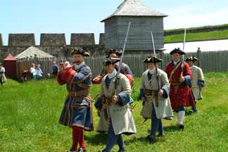
We had come to Louisburg to see the restored French fortified town that was built in the early 1700's to protect the French colonies in the New World against attack by the British. The French and the British were in constant conflict over the lucrative cod fishing on the Grand Banks and around Cape Breton and Prince Edward Island.
The fort changed hands several times in the mid-1700's. In 1760 the British blew up all the fortifications and burnt the buildings and the whole place fell into ruin. Two hundred years later in 1960 the coal mines in nearby Sidney closed and thousands of men were out of work. A $25 million make work project was launched to restore about a quarter of the buildings and walls of the fort. It is now a popular tourist attraction with local actors in period costumes leading tours and serving period foods in the recreated eating houses. All rather touristy, but a fun way to get an impression of a colourful time in Canada's history.
| |
 |
From Louisbourg we sailed in thick fog across the mouth of the St. Lawrence to the French islands of St. Pierre and Miquelon. The history of these Islands is all to do with the cod fishery and the French/English wars in the 17 th and 18 th century. Possession of this safe harbour at the mouth of the St. Lawrence changed hands six times before it was finally ceded to France. In the days of Prohibition, St. Pierre had a booming economy as a trans-shipment point for liquor from Montreal to the US Even today much of the roofing and siding on the old houses is made from crates left behind when bottles were re-wrapped in hessian to eliminate the risk of clanking boxes alerting US Revenue Agents to a shipment being taken ashore at some eastern US port.
We had an easy 25 mile downwind sail from St. Pierre to Fortune where we cleared back into Canada and the next day moved up the coast 5 miles to the historic port of Grand Bank named after the "bank" schooners that sailed from here to fish for cod on the Grand Banks in the 1800's through to the end of WW11. The merchant class and ship owners spent much of their profits on "show" houses, complete with "widow's walks" and elaborate decorations. Many of the houses have been restored and together with the nearby Seaman's Museum, provide a fascinating commentary on the rise and fall of the once lucrative cod fishery.
Summer's solstice, June 21 st, gave us a perfect reaching and running sail for 40 miles to the NW end of Fortune Bay to anchor in quiet solitude in a little bay on the north side of Chapel Island. On the way, we passed dolphins, humpback whales and a pod of eight or more killer whales that came into the bay to feed on capelin that come ashore to spawn at this time of the year. This 4 - 5" fish is a traditional delicacy in these parts and are easily caught and dried. The whales and dolphins attracted the birds...mostly gannets and sooty and greater shearwaters. It was a great day.
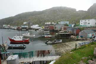
The next day we moved on to McCallum, one of the few surviving outports on this coast. It was first settled by fishermen from St. Pierre in the mid-1500's. All supplies and services for the 110 residents must come by the daily ferry that also takes the day's catch of cod and by-catch to the processing plant in Hermitage. It's all very precarious. However, there is still pride in the community of clean well kept houses and a hope that the 14 children in the school will be the future of the community.
| |
 |
This section of the coast is deeply indented with steep sided fiords. For us, the most spectacular were Hare Bay and Grey River. We entered both in fog, but found that the fog cleared as we moved to the upper reaches and could gaze up at the high, often near-vertical fiord walls. The entrance into Grey River was really hairy. An incoming tide against an outgoing river with big lumpy swells behind us. The entrance is only 1/10 th of a mile wide and the only thing we saw was the breaking waves on the port side as we came in under radar. Our charts for this area were surveyed by the Brits in the 1860's - in small print on the chart is a notice saying that actual GPS positions may be up to half a mile different from positions taken from the chart - this makes our chart plotter less than useful in making landfalls in the fog, and in one instance we entered the wrong bay!
|
 |
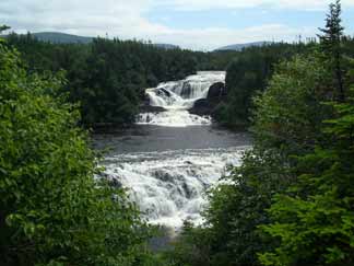
From Port aux Basques we made a 120 mile overnight trip around to Larks Bay, in the justly famous Bay of Islands The SW wind we had been bucking for the past two weeks was now favourable and we had a great sail under poled out genoa's as the wind strengthened during the night. Forty miles further up the coast from the Bay of Islands, Bonne Bay cuts deep into the interior of Gros Morne National Park where we found a sheltered anchorage to leave Taonui while we took a day hike to the rather spectacular three-tiered Bakers Brook Falls.
The coast north of Gros Morne is rather barren with few anchorages so we were thankful for the following wind as we made several long day passages before crossing the Strait of Belle Isle to make our first stop in Labrador at Red Bay. In the late 1500's 2,000 men sailed each year from the Basque area of Spain to the south coast of Labrador to hunt whales. |
 |
The sheltered harbour at Red Bay was the site of their largest whale-oil processing operation. An extensive archaeological under-water and land excavation was carried out between 1977 and 1987 that yielded a detailed understanding of the Basque whaling activity. The best of the discovered artifacts are displayed in a very well presented Parks Canada exhibit that includes an 8-man chalupa used to hunt the whales, and an exact scale model of a galleon that was found buried in the mud at the south east end of the harbour.
|
We saw only two icebergs on the whole trip. We found out why when we contacted the Ice Service in Ottawa, who explained that just as many icebergs as ever are calving off the Greenland Glaciers and drifting south down the coast of Labrador. Normally they are trapped in pack-ice during the winter. But in recent years there has been much less pack-ice on the coast and the winter storms have been able to breakup the ice bergs before they get south to Newfoundland. A rather perverse outcome of global warming. All leading to much disappointment for the tourists along the NE coast of Newfoundland who take tour boats out of towns like Twillingate to see icebergs.
|
 |
| Our last stop in Labrador was Battle Harbour. This was the de facto capital of Labrador from the late 1700's to the early 1900's. It was the logical first landfall for the thousands of fishing families that came each year to coastal Labrador from Newfoundland to pursue the seemingly inexhaustible stock of cod. From June to October the narrow harbour was wall-to-wall with schooners bringing in salt and supplies and taking away dried cod to Europe, the Caribbean and South America. It all came to a crashing halt in the late 1980's when catches plummeted. Starting in 1996 a private and Government funded trust has restored many of the commercial buildings and used them to house an excellent display of photo's, equipment and memorabilia from the heyday of an industry and a way of life we will never see again.
|
Heading south from Red bay we experienced one of those heart-stopping magical moments of nature. A huge Humpback whale breached two hundred yards from the boat. Not once but four times and on the last occasion he (she) was almost totally out of the water, one long white flipper out at right angles and the other wrapped around the body. It was a perfect day, blue sky, 10 knots of SE wind over smooth seas. At least six pods of White Beaked Dolphins had come to say hello before rushing off to chase food. Earlier a fin whale had slowly surfaced off the stern and there were often whale spouts around the horizon. And then this incredible display of grace and power. Why they do it no one knows, but we'll not soon forget this sight. No, we didn't have the camera out and were too transfixed to go below to get it until it was too late and then all we caught were distant shots of a flipper waving in the air. |
 |
We stopped at St Anthony on the north east corner of Newfoundland to visit the Grenfell Centre that houses an extensive collection of artifacts and photographs of the work of Sir Wilfred Grenfell and the Grenfell Mission that was the sole provider of health and education services to the native people and seasonal fishermen of southern Labrador from the late 1890's through to the 1960's. Another place of great interest is 30 miles north of St. Anthony at L'Anse aux Meadows. Around 1000 AD Lief Eriksson brought a group of 70-90 Norwegians from Greenland to establish a settlement here that served as a base for exploration south along the Gulf of St. Lawrence. The site was discovered in 1960 and following extensive archaeological research, Parks Canada has created a most interesting display of the way of life of these intrepid Viking explorers.
We were told that the northeast coast of Newfoundland offers some of the best cruising in the world. There is seldom fog on this coast during the summer and the wind is usually offshore, a great place for gunkholing. However, we saw very few other yachts until we got to close to St Johns.
We had some fine sailing as we moved east across Notre Dame Bay. The wind was south or west and Taonui raced along on broad reaches past some spectacular coastal scenery, massive rock promontories, a myriad of islands, tickles and bays. When it describes Notre Dame Bay, our Sailing Guide says that there are just too many anchorages to describe and the reader should just go off and explore on his own. One could spend weeks here amongst the islands. Next year we'll be coming back this way as we head north to Labrador and we are looking forward to visiting more of the lovely anchorages in Bonavista and Notre Dame Bays.
Taonui spent the winter on the hard at the Royal Newfoundland Yacht Club. |
2007 Labrador and Transatlantic
|
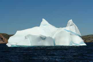
This year the ice was exceptionally late in clearing from the north coast of Newfoundland and Labrador. The previous year there had been few icebergs off Newfoundland. This year we counted seventeen around the horizon as we crossed Trinity Bay, the second big bay west of St John's where Taonui had spent the winter. The crab fishing season started in early May, but many fishermen had been unable to get out through the ice to set their pots, and when they had the ice had often taken out their marker buoys. In mid June the satellite-based ice charts from Ottawa showed 3 - 5/10ths ice from Notre Dame Bay to St. Anthony's and 5 - 9/10ths ice on much of the southern coast of Labrador. You can't push nature, especially ice, so we slowed down and waited as the ice gradually cleared northward. No great hardship as there are many lovely anchorages on this deeply indented coast. |
|
Labrador Iceberg
 |
One special place was Greater St. Julien Harbour. The weather was perfect, and we had an easy hike along the peninsular over moss and lichen covered rock and low heather. Out to sea a dozen icebergs glinted in the sunlight. Three humpback whales were feeding close along the coast. The capelin were back and so were the whales and seals. The fishermen told us that the cod would be coming in soon to join the feeding. Hope springs eternal. Greater St.Julien Harbour was an old outport as witnessed by the gravestones recording the passing of generations of three families, the MacGraths, Sextons and Drudge's, from 1811 to the 1950's. Blood runs deep on this historic island.
|
Breaching Humpback Whale
 | |
Recently we have seen many humpbacks and had the treat of seeing two of them spy hopping and breaching. The capelin (small 6" long fish) were back so there was much furious feeding by whales, seals and sea birds, murres, razorbills and gannets. The only capelin feeder that was not back is the cod. Despite the moratorium on cod fishing in 1992 the stocks have not recovered. One of the great tragedies of our time.
|
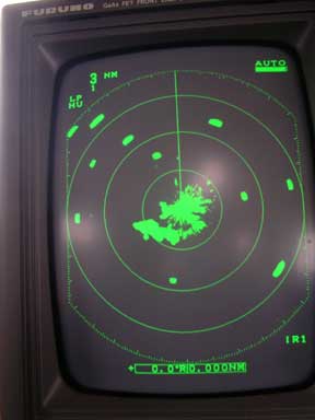
We left St Anthony's on July 3 well stocked with food and fuel with the hope of getting to Cape Chidley at the northern tip of Labrador. As we moved up the Labrador coast the weather remained generally foul with occasional showings of sunshine. Fog was a constant, and we had to stay glued to the radar. This is a picture of a typical radar screen littered with icebergs.
| | Radar Screen with Icebergs
 |
Hawke Harbour
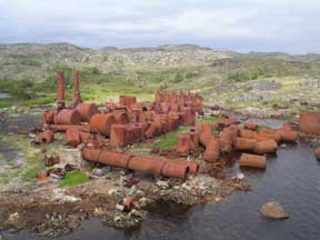 | |
We stopped at Hawke Harbour, 80 miles south of Cartwright, the site of one of several whaling stations on the Labrador coast. It closed in 1959 after processing thousands of humpbacks, blue and fin whales. It used to employ 350 people on shore and 150 on the catchers. Now it's just a big eyesore of rusting boilers and rows of oil storage tanks. Today the whales are free from their only predator, at least in these waters.
|
By mid July the weather turned warmer. A mixed blessing. The bugs were out, and can they bite especially the black flies. We look quite a sight with fine mesh nets from head to waist, but who was there to see.
|
|
Coryn Sporting a Mozzy Net
 |
On July 23 we reached Makkovik, one of the early Moravian Missions established by German missionaries along the north coast in the late 1890's. In 1958 the Moravian's gave up the struggle to support these far flung centres and Ottawa decided to relocate the most northern mission at Hebron to Makkovik. Today, the town, population 300, is a mixture of Innuit and Newfoundlanders. All very friendly and welcoming to their neat little outpost that is now not quite so isolated with daily Twin Otter flights to Goose Bay and weekly visits in the summer by the supply vessel, Northern Ranger. The fish plant was full of hustle and bustle processing snow crabs caught by the three small offshore boats based there. The season was late starting. The ice only left here three weeks before we arrived and there was now a rush for each boat to catch its allotted quota before the "soft shell" season puts a halt to fishing.
Sadly, this was as far north as we were going to go. We had to leave enough time to get back to St. Anthony and get ready for the trip across to England. Although the most spectacular part of the Labrador coast is to the north, it will have to wait for another time.
It was late July and the seasonal shift to more frequent NW winds seemed to have begun. We had a great downwind sail from Makkovik back to Holton Harbour...75 miles in 14 hours, getting in at sunset. The next day 25 knots+ from the SE discouraged any thoughts of moving on, but by Saturday morning the low had moved east and we wound our way through the islands to Smokey Tickle. The early fishermen on this coast must have had a lot of fun naming the islands and passes (tickles, as they called them). Run By Guess Tickle is just to the east of here. Other evocative names nearby are, Icy Tickle, Granny's Boot Cove, Saucy Joe Rock, Slam Bang Bay, Teapot Island, Grandfather Rocks, Cut Throat Tickle, Hell Grapple Head, Horse Chops Island and Mad Moll Rock.
Smokey Tickle Harbour has a substantial concrete wharf that was built in 1990 along with a large fish processing/packing plant. Now, 15 years after the cod fishing moratorium in 1992, the place is a ghost town and we could almost feel the anguish of social and economic loss as we stuck our noses into the rotting houses and sleeping quarters. Such a waste.
The sail south across Hamilton Sound was a pleasure. Smooth sparkling seas, a light 10 knot NW wind that veered during the day and ended up SE and increased to 15+ knots for a final close reach past the islands to the north of Pack's Harbour. The rest of the trip back to St. Anthony was a pleasure. No fog and few icebergs. We had time on our hands and the weather was warm. Gunk-holing at its best. We only needed to travel 15 miles +/- a day and often stayed several days in an anchorage just to get to know the place.
2007 Transatlantic
On August 31, Ron Mazza, an old friend from our days in Toronto, flew into Deer Lake, and drove a rented car 400 miles north to St. Anthony, which Coryn took back to Deer Lake on her way home to Victoria. Ron and I left on September 3 in good weather with a light west wind that soon shifted to the south, giving us a fine broad reach. Just at sunset a pod of five humpbacks huffed and puffed across the bow. One seemed huge with a broad back that looked like a submarine. Earlier a pod of orcas were thrashing around nearby, obviously hunting something.
The wind gradually increased during the night and veered about 20 degrees to the west. Glorious night sailing with a full main and big genoa making 6-6.5 knots in 10 knots of wind. All the constellations shining brightly and around midnight, a big three quarter waning moon came up to flood the sea in light. No icebergs and no ships and better yet no drizzle and fog that is the more typical weather on the Grand Banks. Huey is kind...sometimes. We were still in the cold Labrador Current that kept the temperature around 10 degrees C.
By dawn the wind was up to 15 and by noon it was blowing 20 and the seas were starting to build. Taonui loved it. One reef in the main and the # 2 genoa. Charging along at 7- 7.5 knots. A 994 low moving across central Labrador gave us strong SW winds for the next 24 hours. All in all a fine start to an ocean crossing.
The wind stayed in the SW giving us over 165 mile runs for the next three days. After that the wind went light as we became caught up in the easterly flow underneath the Atlantic High that uncharacteristically was centered over Northern Ireland and had become stationary. And so it remained for several days. Easy sailing, close-hauled over smooth seas but being pushed north of the desired course.
The days were overcast and grey, and the nights were BLACK. No moon, no stars. The phosphorescence of the wake was the only light. Early one morning, around 2 AM, I heard swooshing sounds from the bow. Going forward I found dolphins riding the bow wave. All I could actually see were streaks of phosphorescence and the bursting release of air as they broke the surface to breathe. Taonui just kept sliding along, up and over the low swells and the dolphins kept playing. Magical. Don't they ever sleep? How do they sleep? I sat there in the pulpit for maybe thirty minutes until I got too cold and damp.
By September 13 th the old 1032 mbs High that had served us so well had gone to Germany and a new 1024 mbs High had developed 300 miles to the SW. The barometer slowly dropped all morning and we were now riding the west winds on the north side of this new High. For the first time in 11 days the boat was flat, not heeled on a starboard tack. A pleasure. The sink drains easily, the bunks were flat and if you put something down it stayed there instead of immediately shooting downhill. The wind was still light,10 -11 knots, now on the starboard quarter. With main furled, we poled the asymmetrical chute out to port and the #2 out to starboard. Lots of sail area. Initially there was not enough apparent wind for Albert (our Monitor windvane), so we had to use Otto (autopilot). By noon the wind was up to 15 knots True or 9 apparent, enough for Albert's long, light wind vane to do the job making 6+ knots in bright sunshine. Sliding along in front of the following waves. Life doesn't get much better.
The winds remained light for the next two days and we eventually ended up motoring as we passed the Scilly Isles. The barometer was dropping and by the time we rounded Lands End a stiff SW'erly had built in that held for the next 24 hours giving us a wild ride up the Channel arriving off Portland Bill too late to make it into the Solent in daylight so we anchored in Poole Bay and motored up to Lymington with a favourable tide the next morning. All in all an easy crossing. 2047 miles at an average of 144 miles a day.
2008 Scotland
Taonui spent the winter of 2007/2008 enjoying a well earned refit at the Berthon Yard in Lymington. The decks were repainted and new non-skid laid. The rubbing strake and boot-top were also repainted, a new windlass was installed, the insides of the diesel heater were replaced, as were all the cushions and she was fitted with a new #1 genoa. We arrived in mid-May to find her in first class condition and ready to go.
 We made our first stop was the Island of Alderney in the Channel Islands which cleared us out of the EC. We spent the next day enjoying some quiet walks around the sleepy town and local countryside. Masses of wildflowers. All very pleasant. The prevailing winds in the Channel are west so the forecast of east winds was too good to pass up. Better to go directly to Falmouth while we had the chance. We left around 9 am the next day with a forecast of light NE winds that would increase over the next 24 hours. And indeed they did. Around 3 am we were making 9.5 knots and it was getting very bouncy. We were wing and wing and just flying, with the tide adding at least 1.5 knots. Going down to two reefs in the main and half the new #1 genoa brought everything under control. Just after first light we made our way into the familiar harbour at Falmouth and anchored at the eastern end near the new Maritime Museum. We made our first stop was the Island of Alderney in the Channel Islands which cleared us out of the EC. We spent the next day enjoying some quiet walks around the sleepy town and local countryside. Masses of wildflowers. All very pleasant. The prevailing winds in the Channel are west so the forecast of east winds was too good to pass up. Better to go directly to Falmouth while we had the chance. We left around 9 am the next day with a forecast of light NE winds that would increase over the next 24 hours. And indeed they did. Around 3 am we were making 9.5 knots and it was getting very bouncy. We were wing and wing and just flying, with the tide adding at least 1.5 knots. Going down to two reefs in the main and half the new #1 genoa brought everything under control. Just after first light we made our way into the familiar harbour at Falmouth and anchored at the eastern end near the new Maritime Museum.
After a week in Falmouth visiting old friends, stocking up with food and completing some jobs left over from the work at Berthons, we headed north despite the forecast of northerly winds. Maybe it would be light and we could easily motor against the wind or, maybe the weather gurus would get it wrong. Well, they got it right. It was Force 4 (16 knots) most of the time. We had a fine sail for the first 35 miles along the coast of Cornwall, but once around Lands End it became a real grind. With the tide we made 5 - 6.5 knots, against the tide we made a discouraging 3 - 4 knots. It was a long 260 miles....48 hours of three hours on and three hours off until we made our way into the huge new marina in Dun Laoghaire just to the south of Dublin.
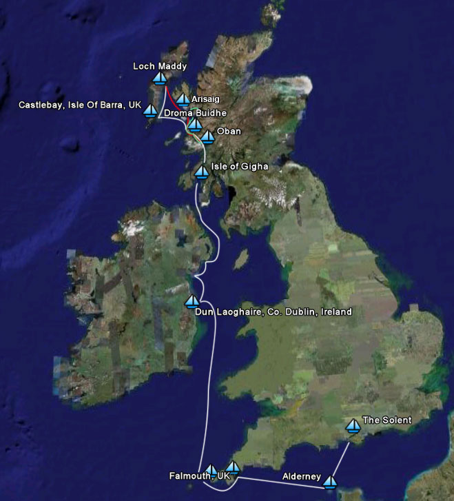
By June 10 we were in the Western Isles of Scotland, anchored off a white sandy beach on the Island of Gigha famed for the Gardens at Achamore House. A great sail to get here from Belfast Lough....65 miles in 9 hours, closehauled, two reefs and the #2 genoa. We started out early one morning at 04:30 to catch the outgoing tide up the northeast coast of Ireland and through the narrows between NE Ireland and SW Scotland. At times we were making 9 knots over the bottom and were able to get past the dreaded Mull of Kintyre, with its fierce currents and overfalls, before the tide changed. The tide can develop a very nasty race well offshore of the Mull. We were caught in it last time we came by and had green water running over the bow and up to the mast.
By mid-June we were in Oban and the weather had returned to normal. Scudding grey clouds and occasional snatches of sunshine between curtains of rain that vary between stair rods and fine Scotch mist. The high pressure that prevailed during much of May and the first half of June has given over to the usual succession of lows. We had a "cracking" sail (to use a southern English term) from Oban up the Sound of Mull, past Tobermory and into the 360 degree protected anchorage of Droma Buidhe
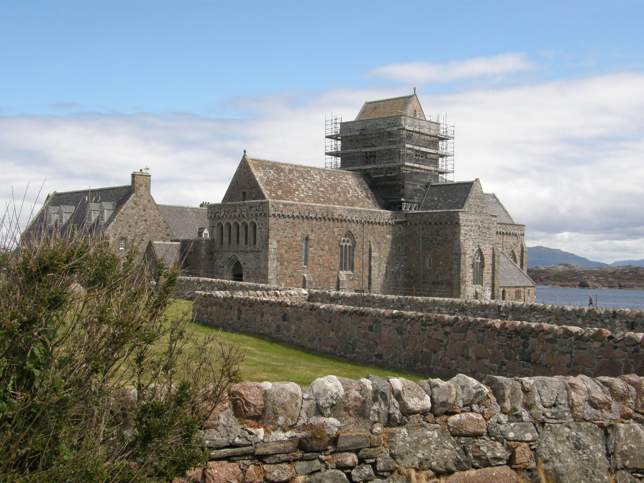
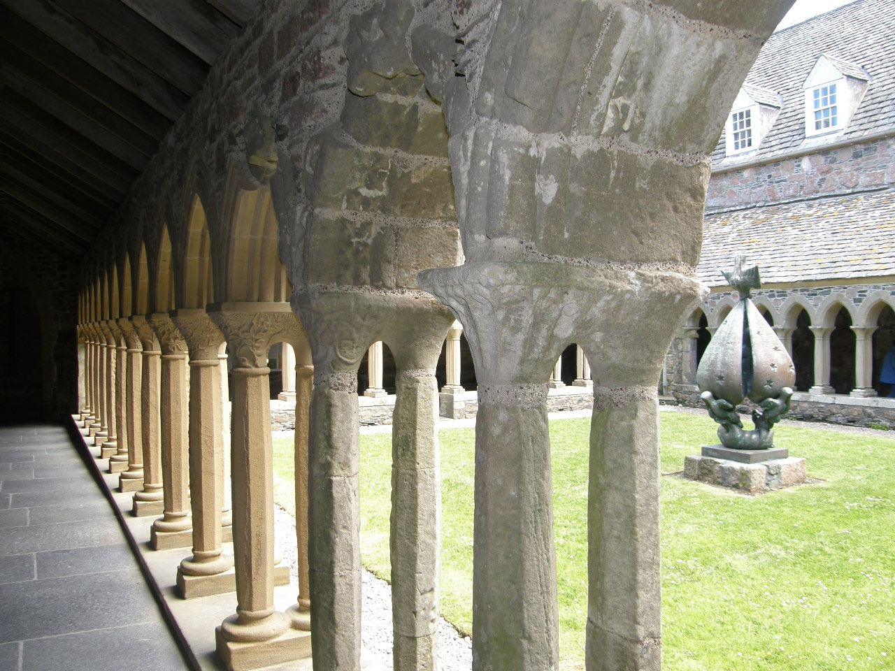
25 miles, often at speeds of 8 - 9 knots, two reefs in the main and ¾ of the #2 genoa, a stiff beam reach and a favourable tide. But it was cold and damp and we were glad to get below and warm up and dry out beside the diesel heater. While we were in Oban we took a ferry/bus/ferry excursion to the Island of Iona to visit the famed Iona Abbey founded in AD 563 by St. Columba who came from Ireland with 12 monks in what was to be the beginning of the re-introduction of Christianity across Europe after the Dark Ages. Most of the church, cloisters and adjoining buildings were built in the 1200's when it became a Benedictine Abbey.
| Iona Abbey |
Iona Abbey Cloisters |
 |
 |
The sail north from Droma Buidhe was a pleasure. Close hauled into a 15 knot NW wind over smooth seas....past Muck, under the towering crags of Rhum, then freed off for the last 3 miles to the sheltered anchorage at Canna.
| The Village at Canna |
|
 |
In the mid-1880's the "Clearances" reduced the population of Canna to a handful of people, left to raise sheep for the Laird. Fifty years ago the Island was acquired by the Scottish National Trust who now maintain it as a working sheep and cattle farm.
We could have stayed several days on Canna as there would have been some great walking, but a steep-sided-low was due in 24 hours. We took an east wind for an easy 25 mile downwind sail across the Minch to Castlebay on the Island of Barra where we sat out the passing of the deep low, tossing about on a mooring in winds gusting 35 knots. |
| |
Vatersay |
| The next day dawned fair so we hopped on the local bus to Vatersay Island where we had a lovely 4 mile ramble that started with a walk along a superb deserted white sand beach that is wide open to the Atlantic, followed by a circuit of the island over grass covered hills. On the south side of the island the track dipped down to run along another beach and then up over a hill and down to a valley and past remains of an abandoned village. The wildflowers were superb and many interesting birds were "spotted". |
 |
| Wildflowers on Vatersay |
Abandoned Village, Vatersay |
 |
 |
From Castlebay to Little Kettle Pool (35 miles) we had a flying downwind sail and again, two days later a further 20 miles north to Loch Maddy. On both days the wind was SW Force 5 - 7 and the only sail needed was half of the #2 genoa, giving us a steady 6.5+ knots of boat speed, sometimes up to 8 knots. Staying close to the coast, the Islands gave us a lee so that although it was a bit of a wild ride, it was quite comfortable.
While in Loch Maddy we took advantage of a brief break in the weather to take a 40 minute bus ride across North Uist and over the recently built causeway to the Island of Berneray, renown for its fertile farms, wild flowers and bird life. As is the case on many of the Hebrides Islands, the exposed western coast is a long white sand beach backed by sand dunes that in turn give way to flat fertile land known as Machair.
The Machair has been created by nature over the centuries from blowing sand, crushed shells and seaweed. There is ample archaeological evidence of man's use of theses lands dating back to 5,000BC... standing stones, burial chambers and the like. The small crofter farms of the 1700's and early 1800's have today been replaced with mechanized farming focused on sheep and cattle to service the growing demand in Europe for organically grown meat.
.
Western Beach, Berneray | .
"The Castle", Rhum |
 |  |
From Loch Maddy we had a fine sail with a NW wind back across the Minch to Rum where the only anchorage is a wide shallow bay open to the east but well protected from the forecast west and NW winds. At the head of this bay is a fine "castle" built in the late 1800's by a wealthy milling machine manufacturer from Lancashire.
The whole island is now owned by the Scottish Natural Heritage who manage it for the preservation of wildlife, particularly a herd of red deer and sea eagles that were re-introduced from Norway in the 1980's and have re-established a population on this mountainous island after being absent for almost 100 years. Rum is a birder's paradise. 150 species have been recorded there. Over 85,000 pairs of Manx shearwaters nest on the grass-covered scree slopes of some very impressive looking mountains. The following day while Coryn went birding Tony had a great hike up into the lower hills. Saw lots of deer and wild goats but, sadly, no sea eagles.
|
Wild Horses, Rhum
|
|
|
After a pleasant stop in Tobermory and then Loch Aline, we returned to Oban where Coryn flew back to Victoria and then north to spend two weeks at Bathurst Inlet, just north of the Arctic Circle. This is a small Inuit community that each year welcomes a limited number of visitors who come to enjoy the Arctic wildlife and botany. Tony stayed in Oban hoping to get some climbing in the nearby hills. The weather didn't co-operate so after a week he headed back up the Sound of Mull and then on to Arisaig to stock the boat and made ready for the trip down to the Azores.
|
2008 Western Isles to the Azores
The great circle distance from Barra to Terceira in the Azores is 1,347 miles. For the most part the course is upwind into the prevailing SW winds blowing on the southern side of the progression of lows that move NE up the Atlantic. Later in the trip the SW wind is from the flow along the northern side of the North Atlantic High. And so it was for this passage. Occasionally the passing of a low gave me a flying reach in NW winds on its western side, but for the most part the trip was hard on the wind with a reefed main and a partly furled #2 Genoa. Life on the slant.
Not being able to lay the required course much of the time increased the distance sailed to 1,478 miles which I covered in 12.5 days at an average speed of 4.9 knots. Each day I emailed Coryn a report that was posted on this website. The report from August 12, describes the typical conditions.
August 5, 2008.
Noon-to-noon 102 miles. To go 755 miles.
What a day! Huey doesn't mess about. Had an easy night sailing west in a light SSW wind. That died around 06:00 as the fog and drizzle set in. The barometer had flattened at 1000 millibar's and presumably this was the centre of the low. But the seas! A swell from the NE and an even bigger wave train from the SW. Couldn't help thinking that a big wind was blowing on the other side of this low. Motored all morning. Little wind, up and down and all about in the waves making 3 - 4 knots at best. Passed close by two ships without visually seeing them. Then at 14:00, while I was trying to sleep, the wind came in. The skies cleared and as I scrambled around, pretty soon it was up to 30 knots. Spray and white caps everywhere and the wave motion got even wilder. Finally settled Taonui down with two reefs and several rolls in the #2. Unfortunately the wind is SW and the best heading is only 180 degrees. Need 224. This is getting to be hard work. Hopefully as this very slow moving low moves east the wind will veer, with a bit of luck all the way round to NW, at least for a time.
17:00 Just tucked a third reef in the main. Wind gusting 35 and Taonui is leaping and tossing over the still jumbled seas. Just speared one that covered the boat in water. Thankfully the companionway is totally shut as I'm sitting right under it. Anyway, the centre of the low has passed (or I passed it). The barometer is rising. This too shall pass.
21:30 That was some of the wildest deck work I've had to do. You have to be careful what you wish for. Huey is perverse. The wind went into the NW and really picked up. I ended up taking down the main and lashing it up. All the while Taonui was flying along at 7+ knots, dragged along by half of the #2 genoa. Thank goodness for the new Musto wet weather gear I bought in Falmouth. I stayed dry while buckets of water (make that big buckets) were flying around. Now on a beam reach, half the #2 genoa, right on course, making 7.5 knots+. Wind 30 gusting 35+. The waves are lining up with the wind, so not crashing up and over them as before. Still a bit of a wild ride. What a great boat she is.
As I neared the Azores, and came under the influence of the High, conditions improved, the temperature rose and shorts and T-shirts replaced foul weather gear. The last part of the report for August 9 tells it all.
20:00 It is one of those perfect evenings. Clear sky. Clouds only around the edge of the wide horizon. Half a moon, some early stars. Orange glow low in the west. Itzhak Perlman playing Bruck's plaintiff Scottish Fantasy. Taonui sliding up and down the now lower ground swell. 4.5 knots of boat speed, ten knots of apparent wind, broad reach, 15 degrees high of course. Perfect.
The municipal land behind the marina at Praia da Vitoria on Terceira Island is used for a summer festival and I had to wait until August 30 th for the festival tents to be removed so that the land could be used for storage of yachts. This gave me plenty of time for the usual maintenance projects, cleaning, and a thorough job of laying her up for the winter. I had time to explore the main town of Agra with some buildings dating back to the 1400's and to make a circuit of the Island by interconnecting municipal busses and hitchhiking. Aside from the US Airforce Base at the NE end, the island is devoted to small farms and a few tourist establishments. All very quiet and peaceful and a great place to leave Taonui for the winter.
2009 Brittany and Ireland
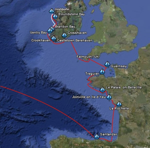 Taonui spent the winter of 2008/09 in the parking lot of the Vittoria Marina on the island of Terceira in the Azores. I arrived back in the Azores on April 24 th with the plan of sailing to Santander on the north coast of Spain where Coryn was due to arrive by ferry on May 14. Taonui spent the winter of 2008/09 in the parking lot of the Vittoria Marina on the island of Terceira in the Azores. I arrived back in the Azores on April 24 th with the plan of sailing to Santander on the north coast of Spain where Coryn was due to arrive by ferry on May 14.
For the two weeks it took to get Taonui back in the water and ready to go, the wind was SW and W, perfect for a trip east to Spain. However, three days later the North Atlantic High turned into an elongated fat sausage and moved north leaving a stationary band of E and NE winds blowing over the Azores with no forecast of a change in the next five days. I was starting to run out of time, and had to leave if I was to cover the 1,057 miles to Santander by May 14th.
I waited until the afternoon of May 5th hoping that the wind might ease. No chance. It took four men to push Taonui off the dock where she was pinned by wind gusting 25 knots. The previous night a big fat red fender was squashed between Taonui and the dock. Thank goodness there was a large outer harbour at Praia da Vittoria giving plenty of space to get sails up etc. before heading out with a double reefed main and 2/3's of the #2. The best course I could make was due north. The required course to the NE corner of Spain was 78....right up the wind.
As expected, further north the winds eased and the wind shifted more to the east. By noon on May 6th Taonui was carrying the #1 genoa and full main making 5 - 5.5 knots and 20 degrees. Required course was 81 degrees. The seas were down but still uneasy. By the next day I expected to be motoring across the high and later into light west or north winds. Taonui was in great shape and it was good for the soul to be out on the wide ocean again.
By the evening of the second day out I was north of the band of strong east winds and enjoying a glorious night's sail, close-hauled against a light NNE wind, making a comfortable 5 knots. A huge full moon had chased away all but the brightest stars. Albert (Monitor self-steering) did the steering, so all was quiet. Unfortunately it didn't hold much past dawn when the wind went on the nose and died and I had to motor for the rest of the day.
After several days of light winds, mostly from the East and Northeast I arrived off Finistere on the night of May 12 and what a long night it was. I have never seen so much traffic in such a small area. Aside from numerous fishing boats going every which way, there was a procession of big ships rounding the NW corner of Spain. I was 40 miles offshore, hoping to keep out of the worst of the traffic. Very little wind, so under motor until around 2 AM. Not much sleep either as there was always one and often four or five close-by targets on the radar screen. Around dawn the new southerly wind had built, and Taonui was sailing again on a broad reach making 6 knots, sometimes more. By mid- morning the wind was lighter and had shifted into the SW. Speed dropped to 4 knots, but it was sunny, and the seas were smooth as I headed south of east, closing the coast until I could see snatches of the hills of northern Spain. I figured that I might get in at last light the next day, certainly by early morning on Thursday. Coryn's ferry from Portsmouth would arrive Thursday at noon.
I arrived off the harbour entrance at sunset on May 13th. Thankfully it was perfectly calm, and there was enough city-light to find the way down the rather windy channel and into the marina, which is quite a way away from the city itself. I had been lucky with the weather, as around 4 a.m. a front passed by. Lots of rain and wind and by dawn it was blowing 25 plus. No way that I could have come in under those conditions. Would have had to anchor in the harbour and spend the night worrying if some ship was going to find me in the wrong place.
Coryn left Portsmouth in smooth seas, but had a rough night and morning and so was very glad to be on dry land when I met her at 1 PM.
Spain
Sailing along the coast from Santander our first stop was Castro Urduales, a large, rather unsettled bay where we anchored outside of all the local boats. On the headland is an imposing four towered castle built by the Knights Templar, and nearby a rather delicate large Gothic church that dates back to the 13 century. The church was on the pilgrim route to Santiago de Compostela, near La Corunna. We stayed a couple of days and enjoyed walking in the old city and getting a taste of how the Spanish lived including the siesta from 1:30 to 4 or 5p.m. and then back to work until 7 PM.
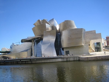 |
Our next stop was Getxo, at the mouth of the river leading up to Bilboa. Rather grand houses line the terraces overlooking the beaches and harbour. A fast ride on the Metro into Bilboa took us to the world famous Frank Gehry designed Guggenheim Art Gallery. Reckoned by many to be a triumph in avant-garde architecture, it is more like a huge sculpture than a building. Swirling shapes clad in titanium, offset by slab sided walls of white limestone and glass curtain walls. It houses a collection of modern art which we gave a miss, but we spent two hours walking around and up and down the outside of this outstanding building.
|
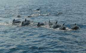
France has a 60 mile long military firing range, extending 45 miles out to sea, from its border with Spain in the SE corner of the Bay of Biscay. To avoid this area, we decided to make a 190 mile passage directly to La Rochelle. It turned out to be an easy trip. A weak low over Spain moving east gave us light NE winds to begin with, followed by light NW and W winds. The first night was a bit scary as two bands of thunderstorms passed over us with impressive pyrotechnics. The second night was a treat. Smooth sailing under a starlit sky with occasional visits from pods of Atlantic White-Sided Dolphins making startling phosphorescent streaks and explosions as they played around Taonui's bow.
Brittany
La Rochelle, such a romantic name and the place in France more likely to come to our minds than Paris. It is the center of yachting in a country that is mad about sailing. Maistral, our previous boat, was built here in 1967. The marina at the entrance to the harbour moors 3,000 yachts, and it is planned to expand next year to 4,000 slips. We went there when we arrived, but were told that, in that it was coming up to high spring tides, there were no visitors' docks that could handle our modest 6.5 foot draft. So, in the afternoon we took the incoming tide up to a basin off the Vieux Port where there are places for "big" yachts.
We spent a week in La Rochelle wandering around the historic old part of town, shopping in the numerous chandleries and learning to love Brittany cooking and fine wines. We hired a car for four days to tour the area to the north, known as the Vendee, renowned for castles and abbeys, churches and medieval towns, big fat jersey cows and lovely grey horses, fields of poppies and endless flat rich farmland.
The 35 mile trip from La Rochelle to Les Sables d' Olonne was a pleasure. Smooth seas from the offshore wind that gave us a broad reach to get around Ile de Re and then close-hauled for the last 20 miles. For the past three weeks, a high pressure system had been stationary over France, and the wind had been from the east to northeast 12 - 15 knots. Bright blue, cloudless skies.
Les Sables d' Olonne is the home port for the most demanding of all yachting endeavours, the solo non-stop race around the world, the Vendee Globe. It is held every four years in what are known as Open 60s. Sixty feet of functional beauty, capable of daily runs of 400 miles and more. Thirty boats started in the 2008/09 race, but only twelve finished. The winner finished in 85 days. The finish line is between an offshore lighthouse and a navigation buoy and as we sailed across this line and on into the port we doffed our hats to these incredible sailors - and to "Geech", the virtual Open 60 that we "sailed" in the internet simulation of the race that attracted over 270,000 mouse-driving armchair sailors.
From Les Sables we sailed up the coast to Joinville on Ile d'Yeu. Leaving early, we were able to carry the ebbing tide for most of the morning over smooth seas and under a cloudless sky. Taonui just loved it. Six to seven knots on a close reach got us into the small harbour in time for a late lunch ashore, after which we hired bikes for a cycle around some of this picturesque flat island. It attracts many tourists in the summer who come over by ferry for the rural peace and the intimate beaches that ring the island.
It was too much to expect that all that lovely high pressure weather would last. On June 6 it broke, and one low after another swept over Brittany. We used a gap in the lows to take a favourable tide and a beam reach from Joinville to Ile Houat where we anchored off a mile long crescent beach with the Gaelic sounding name of Treac'h er Goured. We walked for miles along the fine yellow sand beach and then back over the sand dunes that were covered in grass with a profusion of mauve carnations and other small wild flowers.
| The next day, Saturday, was hot, muggy and threatening with a forecast to match, so we raced north to get behind the Quiberon Peninsular and into the marina at Port Haliguen. And there we stayed for three days as the wind alternated between NW and SW, Force 5 - 7, with drenching rain in the squalls. However it was a pleasant enough place to be with some good walks around the old harbour and to the north. Also a good place to re-stock with food and wine...great cheeses. |
 |
| |
Inner harbour La Palias |
| After a few days we left Port Haliguen thinking we could get to Lorient and run up the river which we had been told was very beautiful, and would be a good place to shelter from the next low. The wind was forecast to be WSW, but turned out to be WNW and strong. So we ran off to Le Palais on Belle Ile and tied fore and aft to buoys in the outer harbour waiting for the afternoon high tide when we could lock into the basin and be perfectly sheltered from the strong east winds that were forecast for early the next morning.
|
 |
Our next stop was the Odet River. After stopping briefly at Benodet we went further up the river and anchored in a peaceful estuary for three days. On the second day we rowed to the head of the estuary at high tide with the plan of walking to the nearby village of Corbin. We left the dinghy tied to a tree at the high tide mark, scrambled up the wooded bank and set off across several hedgerowed newly mown hay fields until we found a track that became a road through a dense forest area and finally led us to the village. After coffee, croissants and a checking of emails at the little library, we headed back. As expected the falling tide meant we would have to carry the dinghy down a sloping mud bank to the water about 30 feet away. No problem. On with rubber boots, turn the dinghy around, lift. We've done this a hundred times, but after a few steps we were sinking into the mud. Another step each and we were up to the tops of our boots. We could slide the dinghy, but we were stuck. It took a monumental effort to extract one leg, but in doing so the other sunk even deeper. The mud was like wet cement. Luckily Coryn felt a small rock under her foot and stood on it, one foot on top of the other. I pulled my foot out of a boot but couldn't pull the boot out of the mud. Then we hit on the idea of laying an oar on the mud and standing on it. I used the other oar to dig out my lost boot and then gave the oar to Coryn to stand on. And so we made it down to the water, moving the oars down the beach three or four feet at a time and sliding the dinghy between us. If one of us had fallen we would have been in real trouble. But what a mess to clean up when we finally got back to Taonui.
From Benodet it is a long haul to get through the Raz du Sein and the Chenal du Four to the north coast. So we broke it into stages, first stopping at Audierne and leaving early the next morning to get to the Raz at slack tide and then carry the rising tide into Cameret which was a pleasant and useful stopping place. Deep water access and a good marina on one corner of an almost circular bay ringed with brightly painted old houses rather reminiscent of Tobermory in Scotland. Now a tourist attraction, the town has been cleaned up, and the narrow lanes are lined with artists' studios, trendy furniture shops and little eateries. We happened to be there on market day when one area is given over to street stalls selling great foods, fish, cheeses, together with clothes, books etc.. We found a hairdresser and Coryn came out sporting a cute, short "French" haircut.
After a three day stop, we left Cameret at dawn so as to reach the southern end of the Chenal du Four at slack tide, but at the northern end we were making 8 knots over the bottom despite a ten knot head wind that set up a nasty chop. The wind stayed on the nose as we turned east and Taonui was tossed and rolled around as we became exposed to the westerly swell coming around the north side of Ushant. We were more than glad to get into the shelter of the offshore islands and up the river to L'Aber Wrac'k.
The waterfront at L'Aber Wrac'k has been rather ruined by a large ugly convention centre and adjoining extensive sailing school. But, on the hills behind there are lovely old houses nestled behind tall hedges and stone walls, protecting neat, colourful flower gardens. We stayed three days, but decided to leave when the forecast indicated east winds for the rest of the week. We didn't like the look of any of the harbours along the coast to the east, particularly in the then blowing north winds, so we opted for a long 65 mile trip in one day to get to the highly recommended Le Jaudy River leading to the old cathedral town of Treguier. The first part of the trip was a bit of a misery, bucking the ebbing tide with ground speed down to three knots, but around noon the tide turned, the seas went smooth and our speed came up to eight knots. Sadly the wind stayed light so we had to motor the whole way so as to get in through the outlying reefs and islands and into the river before nightfall.
| |
The Beaches of Guernsey |
| By June 22 we decided to end our leisurely cruise along the coast of Brittany. It had been a real treat and quite an eye-opener. We had no idea this area was so beautiful. A coastline of picturesque old fishing ports, now converted to tourism; long sandy beaches in the south, that give way to outstanding rocky seascapes in the north, excellent food and good wine. It doesn't get any better. And the French that we met were charming and helpful. We have always been turned off by stories of dangerous tides, crowded marinas and anchorages so had never taken the time to come down here and had always, on leaving the south coast of England, gone north or south, down the Atlantic. Well, we are glad we have rectified that.
From Treguier we motored to St. Peter Port in Guernsey. The inner harbour is protected by a man-made sill that holds the water in as the tide falls. The sill can only be crossed two hours either side of high water. Not very convenient and the place was packed with boats. So we stayed in the outer harbour and came ashore by dinghy. |
 |
One day we took the local bus and made a circuit of the island. The western side is a series of beautiful bays and yellow sand beaches, punctuated by rather dramatic pink granite headlands. Offshore there are many nasty looking jagged rocks. The tide range is 30+ feet, so at low tide these gently sloping beaches stretch for miles. At nearby St. Malo to the east, the tide retreats for 12 miles!!
Guernsey is famous for its tomatoes and milk, but today the economy is based on tax shelters so there are a disproportionate number of accountants and lawyers living in the Channel Islands all enjoying a very nice life style. BMWs and Audis are the cars of choice. Guernsey is roughly nine miles by three miles and rather densely settled. The old farm houses and workers cottages have been whitewashed and gentrified and there are many new tastefully designed houses hiding behind hedgerows and surrounded by lovely flower gardens.
From Guernsey to Falmouth the wind was from the east but not enough to sail at more than 2 knots so again we motored the entire distance 110 miles. Boring! and not environmentally friendly. The English Channel is not a part of the ocean to hang about in as we were crossing the traffic lanes with their continuous flow of ships in and out of southern UK and northern European ports. The onboard AIS display (a sort of radar system) often showed six or more ships within 12 miles heading in all directions and at various speeds so we were kept on our toes.
We stayed ten days in Falmouth, much longer than we intended, but it's a lovely old interesting port with much history amongst the narrow cobbled lanes and alleyway's. We seem to always stop there on the way to somewhere. We counted up and found that this was our 11 th time in Falmouth. It was also a good opportunity to touch base with old friends and do some serious re-stocking of cans and other staples.
Our next leg was to be a 180 mile overnight sail to Ireland. 10 miles due south and southwest to get around The Lizard, 20 miles due west to get past Land's End and then 150 miles northwest across the Celtic Sea to the mouth of the river running up to Cork. Against the prevailing west winds some of this trip was going to be hard work and the strong tides also had to be accommodated. The weather forecast one Sunday morning was good and bad. The good bit was southwest winds which would give us a broad reach across the Celtic Sea. The bad part was that the winds would be Force 4-6 gusting 7. The first 10 miles was hard work - the wind was on the nose, and the seas left over from the strong west winds that had been blowing for much of the last week made it all very uncomfortable. Although we timed it to arrive at slack water off The Lizard, there were still overfalls and confused lumpy waves 5 miles offshore. Then the wind died and we had to motor heading for Land's End with the tide behind us. Eventually the southwest wind built back in again and we could sail close-hauled and just clear Runnelstone Light, due south of the point. Again the confused seas tossed Taonui around and we were more than happy to get clear and head NW. It turned out to be a fast rough ride. The wind steadily increased to 25, gusting 30. With three reefs in the main and half of the inner genoa Taonui roared along at 7+ knots. As we approached the Irish coast the wind lightened and we decided to let out a bit more of the genoa. Huey had been at it again. The genoa furling was jammed. We could neither let it out or furl it up. We headed into the coast to the west of the harbour entrance where we found some shelter from the wind and seas, and dropped the main and, heading dead down wind, we hauled the genoa around and around the forestay until it was completely un-furled and then dropped it on the deck.
| We were in Glandore for the annual festival of classic yachts. The final day was a sailpast of over eighty lovely old boats from 15 to 45 feet, mostly gaff rigged with photogenic tan sails. We were anchored in the nearby harbour of Union Hall, close by one of the procession's turning marks, so we had a great view as they showed their stuff reaching around a triangular course in a fresh breeze. That evening a loud band played 60s songs, and at midnight we were out of bed to watch a spectacular fireworks display... no quiet wilderness anchorages around here.
Union Hall is home base for one of the few remaining offshore trawler fleets in south and western Ireland. For the past 20 years European fisheries have been micro-managed from Brussels. Quotas are set for each species for each area.
Catches of fishes that are not being targeted by a boat on a given day are discarded. Many tons of fish are discarded at sea every year. Fish stocks are steadily declining. Fishermen are going broke. Boats are poorly maintained. |

|
Everyone is disappointed or mad. Sadly there is no political will to make any serious changes in regulations... just minor tinkering, which drive the fishermen squirly. Until offshore fishing becomes viewed as "farming" instead of "hunting", there will be no reversal of the decline. The recently released film, End of the Line, based on the book of the same name, is causing some heated discussion, particularly it's focus on the impending demise of commercial fisheries throughout the world.
On July 21 we had a lovely sail from Glandore to Crosshaven. Sliding along over smooth seas in warm sunshine, past craggy cliffs backed by fields in shades of green and yellow picked out by ancient low stone fences. A variety of bird life to enjoy... murres, shearwaters, fulmars, guillemots, cormorants and gannets. We were at the wilder bend of Europe, the southwest corner of Ireland. The seas seem clearer and must still be supporting lots of fish. Crookhaven is a shallow, safe anchorage just to the east of Mizen Head where Marconi set up the first trans-Atlantic radio link. We were here in Taonui in 2000 and 29 years ago we landed here in Maistral at the end of our first crossing of the Atlantic. Back then there was a pub and a few fishermen's cottages. Now the place is alive with a huge youngsters' sailing school, lots of pleasure boats and many recently built modern-looking houses. O'Sullivan's Pub is still there, but it is now flanked by several stores, restaurants etc.. The past thirty years have seen tremendous economic growth in Ireland triggered by its entry into the EC. However the recent worldwide recession has hit hard. Several banks collapsed, and unemployment is around 12%, though you wouldn't know it looking around here. It was the holiday season, and everyone was having a great time in their new yachts, powerboats, seadoos and Zodiacs.
That day a deepening low swept in from the SW and the centre started to track up the west of Ireland. The east wind was building as we came back to the boat after dinner at the local pub, and by early morning it was blowing Force 5 with higher winds forecast as the wind backs into the south and then SW. A good down-below day reading the weekend's papers!
Heading north from Crosshaven we stopped at Castletown Bearhaven and Ventry Bay and then Brandon Bay where we had to wait for three days for a deep low to slowly make its way up the coast.
The 65 mile sail from Brandon Bay to the Aran Islands was very much like being back in the Southern Ocean. The forecast was for W to SW Force 5, but stronger in the coming three days, so we decided to make a run for it while we could. In the event it blew 30 knots (Force 7) much of the time. The waves were around 15 feet, sometimes bigger. Taonui had a great sail, flying along at 7.5 knots, sometimes over 8 knots with three reefs in the main and half of the #2 genoa unfurled. Thank goodness for Stugeron for Coryn as the corkscrewing motion on a reach in big seas is very uncomfortable to say the least. Later the wind went more into the SW and we could go wing and wing running just about dead downwind with a better motion.
The harbour on Inis Mor, the biggest of the Aran Islands, is well sheltered from southerly winds, so we were quite comfortable as the wind increased the next day and night. For 5 days we had not been able to get off the boat due to strong winds but July 29 dawned clear, calm and sunny. A great day to be a tourist, taking a taxi out to marvel at Dun Aonghasa, the massive late Bronze Age (800 BC) fort built on the highest point of land on the island. The fort encloses about 14 acres of land and is comprised of a semicircular walled enclosure, open to the sea on the southern side and surrounded by three further roughly concentric walls, all of which terminate at the cliff edge with a sheer drop of over 300 feet to the pounding Atlantic waves below. There are three other dry stone forts on the islands and a number on the mainland, but Dun Aonghasa is by far the biggest.
The Islands are crisscrossed with dry stone walls enclosing small fields, often only around 500 square feet. We were told that most of the fields were created by quarrying the bare rock, using the stone to build the wall, and then slowly over years creating soil by hauling seaweed up from the coast. The soil was mostly used to grow potatoes and raise milk cows. The disastrous Potato Blight of the 1840s ruined the crop, here and across Ireland, causing widespread starvation. Over 1 million people died and many more left the country for England, Australia and North America. Today there is little farming. The seas have been fished dry. Over 3,500 people lived here in 1841. Today there are only 900 residents living off tourism and welfare.
On July 30 th we hoped for an easy motor west to Roundstone Bay where we would wait for favourable conditions to round Slyne Head (big tide race), and then head north to Inishbofin. Despite an early start, when the wind is usually lighter, it was not to be. The wind built to over 20 knots and it was a long grind, motoring and beating for 20 miles until we could ease off and run into the bay. We anchored for lunch just inside the entrance in a semicircle of a brilliant white sand beach, complete with water-skiers, kayakers and tentative swimmers from a large holiday camp on the north side. This was no anchorage to sit out the forecast gale, so we moved deeper into the bay to a recommended anchorage in only 15 feet of water close to the southern shore. Later in the day we had to move again to find shelter from the forecast wind shift that night.
The trip from Roundstone to Inisbofin wasn't too bad and we got there before the weather turned foul again forcing us to wait there for four days as a very slow moving deep low made it's way north 200 miles off the Irish coast and finally dissipated north of Iceland. Although the anchorage was well sheltered from the wind, the huge swells generated by the constant Force 5 - 7, gusting 8, SW wind made through the narrow entrance, bounced off the northern shore and sent an uncomfortable chop and surge across the harbour. So, for four days we rocked and rolled and had to "hold on" moving around the boat.
Most days we took a wet dinghy ride ashore just to get off the boat and on to solid land. It is a great place for long hikes over the rolling hills with visits to beautiful sandy beaches, but all that is not much fun in driving rain and buffeting wind. In the short summer season many tourists come over from the mainland to what is essentially the westernmost point of Europe. They come for the excellent hiking and birding and for scuba diving in the clear, clean Gulfstream-warmed waters. The ruins of the fort guarding the harbour entrance are an added attraction. It was built by Cromwell in 1653 after the Parliamentarian Army swept across Ireland destroying all the Catholic churches and monasteries. The fort was equipped with 22 cannons and was aimed at dissuading the Irish and their French allies from retaking this then important outpost that controlled the trade routes into Galway and up and down the Irish coast to Scotland
We decided that Inisbofin was as far north as we could go and still leave enough time to get south against the prevailing SW winds to reach Castletown Bearhaven in time for Coryn to get back to London on August 28 and for Tony to head south to the Canary Islands where Taonui was going to spend the winter.
With a forecast of light SW winds, we left Inishbofin late on the afternoon of August 6 with the hope of getting an ebbing tide through the Blasket Sound the next day. It turned out to be a real struggle, one of the hardest slogs we have had in a long while. The big swells were still there and by dawn the next morning the wind had backed into the SSW so that we were forced east to Loop Head and that's where the hard work started. We tried motoring but the swells and building wind knocked the speed down to 2.5 - 3 knots. So we went down to two reefs and a reduced #2 and tacked back and forth for six long hours against the big seas and the now contrary tide. We gave up on getting through Blasket Sound and instead beat our way deep into Smerwick Bay to anchor off a long sandy beach.
The next day, the wind had dropped, the barometer was rising and we had an easy passage through the Sound and then a lovely close reach for 15 miles over to Valentia Island. We spent a week in the Kenmare River stopping at some lovely sheltered harbours on both sides of the river.
Our favourite place was the beautiful intricate waterways of Sneem Harbour. The village of Sneem itself is at the head of the harbour which dries for four hours either side of low water. Conveniently this was at mid-day, so in the dinghy we took the tide up in the morning, walked 1/2 a mile along a delightful riverside park to the picturesque village with it's central market square that had been turned into a park displaying two striking sculptures, had a great pub lunch, did some shopping and took the afternoon ebb back down the river.
We arrived back in Castletown Berehaven on August 26. Coryn left a few days later for London and back to Victoria while Tony made final preparations for the trip to the Canaries.
Ireland to the Canaries
The first 500 miles was a real struggle, beating against the almost constant SW winds from a series of lows tracking to the west of the Bay of Biscay. The log entry for August 31 is typical
August 31, 2009. Noon 47 51N 7 41W. Noon-to-noon 120 miles. CMG 151 degrees. Required course 204, Miles to go 1,160.
Not a great day. Although I sailed, with tacking, more that 120 miles I only made good 84 miles. The SW wind won't let me get west and Taonui is being "sucked" into the Bay of Biscay. This Bay has a reputation for bad weather, almost always westerly, and on the shallow water that extends a long way off shore, the seas can be fierce. The old square-riggers dreaded being "em-bayed" as they called it. Trapped, with a potential lee shore on three sides.
It didnt get any easier until I got south of Cape Finistere. The log for September 2nd tells the story.
September 2, 2009. Noon Position 44 15N 8 45W. Noon-to-noon 110 miles. Miles to go: 940.
.
Eventually I made it south of Finistere and out of the influence of the lows. The NE trades kicked in and life returned to an even keel. The following log report describes sailing as it should be.
September 5, 2009. Noon position 39 16.7N 11 08W. Noon-to-noon 164 miles. 625 miles to go.
From the log book.
| What a pleasure. I love to stand in the cockpit, leaning over the dodger, looking forward, almost mesmerized, watching Taonui move. The effortless transformation of the wind's force to a functionally perfect creation. So graceful. Surfing down the six foot waves. White water coursing down her sides. No fuss, no effort. With twin headsails, Albert has an easy job keeping her on course, dead down the wind. The wind is a steady Force 5, 20 - 22 knots. The waves are lined up, all going the same way. I had almost forgotten the pleasure of downwind sailing. Averaged 6.8 knots for the day's run and if this keeps up (he said in a soft voice, lest the fates be tempted) I should be there in four days.
With no ships to worry about and no sail changing to do (all I've done is reduce sail area by a couple of rolls in the #2 and 6 in the #1 to make them roughly the same area), I've had time to clean up down below, catch up on sleep and reading, and enjoy watching the sea go by. |
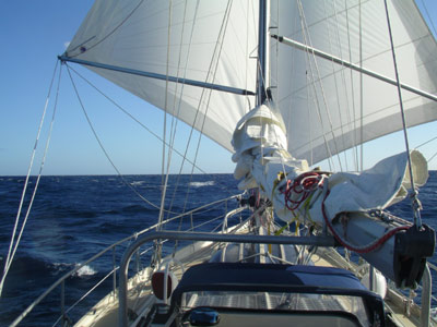
|
I arrived at Puerto Calero at 3 AM on September 10 and spent the next ten days stripping the decks and rigging, laying her up for the winter, including erecting a strong (Newfoundland built) cover over the cockpit and pilot-house.
2010 Canaries, Bermuda and Maine
Canary Islands.
Taonui was no worse for wear after spending six months in the water at Puerto Callero, Lanzarote . A bit yellow/brown from the dust blowing over from the Sahara, but no wear on the lines or any other damage. Clean and dry down below. It took five days to get the sails up, running rigging re-run, radar back in place and a number of other maintenance projects completed, including re-wrapping the exhaust pipe that I had stripped of lagging at the end of last season. A leak from the starboard diesel tank had soaked it in fuel and also ruined the glue holding the sound deadening on the forward engine cover. Taonui was hauled out to pressure wash the bottom, put grease in the propeller casing and replace the propeller zinc. Actually the bottom was surprisingly clean, but I couldn't believe the barnacles and encrustation on the propeller. Serious work with a chisel required.
Before the haul out I took a day off and played the tourist, taking a bus tour of the north end of the Island with the prime attraction, the home of Cesar Manrique, Lanzarote's most famous son, known for his Picasso-style art and for the creative genius as a designer and architect as displayed in the home that he built for himself in five adjoining "bubbles" in a lava flow. The black of the lava contrasts dramatically with gleaming white walls. Full sized windows gaze out over the lava flow and up to the volcano. Manrique died in 1996. His house is now a museum housing selections of his art. Along the tour we saw a number of Manrique's fabulous mobile wind statues and other outdoor sculptures. The last stop was the Jameos del Agua, a breathtaking Manrique creation of an intimate auditorium, concert area, restaurants and bars set in a lava tube that had fallen in in two places. The two areas exposed to the sky are joined by a high roofed tunnel that is open to a flow of water from the sea. Look at http://www.fcmanrique.org for some background on Manrique.
| The Farmer by Manrique |
Wind Mobile by Manrique |
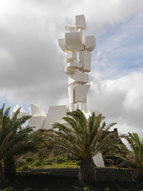 |
 |
I left Lanzarote on March 28 to sail through the Canary Islands to Gomera, the traditional jumping off point for a passage across the Atlantic. Columbus left from there on both his trips.
As expected it was a mixed bag of strong winds funnelling between the high island and dead calm in the wind shadows to the south of each island. I arrived off Las Palmas at dawn on April 1 after a LONG night. I had left Gran Tarajal at 3 PM expecting an easy downwind run down the east side of Lanzarote, then broad reaching around the bottom of Isla Feurteventura and then 60 miles across to Las Palmas, arriving at first light. Well the wind direction prevailed, but it was no easy run. With the setting sun the wind increased to 25 - 30 knots with seas to match. Thankfully I hadn't bothered putting up the main. Certainly didn't need it. Taonui just took off. With only half of the # 2 genoa she was making 6.5 - 7 knots, often surging to 7.5 knots. There was some respite with a bit of a lee under the very foot of Feurteventura, but once out of that and onto a broad reach the rock and rolling sleigh ride was on again. I reduced sail further to cut the speed back to 5 knots which only increased the motion. That and the fair amount of traffic didn't allow much sleep. <
By 4 AM I was 5 miles from Las Palmas, so I turned around and sailed a reverse course for 5 miles. With Daylight Saving it doesn't get light until 7:30. I'm glad I waited. The place where I anchored in 1999 is now a container port and there is a huge new yacht marina area. After much filling out of forms (all on computer) the marinero helped me moor Taonui stern-to amongst a crowd of live-aboard yachts. Taonui, to her credit and my gratitude and surprise, backed straight into a slot between two boats with no fuss, no muss. <
The past ten years have seen a massive development in the tourist infrastructure in the Canaries. The development of hotels and tourist housing along the east coast of Fuerteventura is staggering. The island itself is a barren line of old volcanoes. Not a sign of green. But along the coast, wherever there is a valley or flat land, there is a development often extensive, of 10 storey and more hotels and side-by-side housing often running up the hillside for a 1/2 mile or so. Las Palmas, always a major town, now sprawls south from the nobble of an old volcano at the NE end of the Island. Highrise buildings line the coast, and freeways cut through the town. Nothing peaceful about this place anymore.
April 8 I reached San Sebastian on Isla Gomera. after a long 80 mile, 15 hour day. Left at 4 a.m. and had to motor for the first two hours until I got out of the wind shadow of Gran Canaria. Quickly the wind built and in pitch black darkness (it doesn't get light until 7:30) I went from motoring to close reaching in 25 - 35 knots with three reefs in the main and less than half the #2 genoa. And so it kept up all morning for 50 miles, making 7 - 8 knots, spray everywhere. Thank goodness the seas were not big, but the decks got a thorough washing. Then BANG. It was like going through a door. The wind stopped. Stopped by the big 3,718 metre high mountain range on Tenerife. So on with the motor for 15 miles, after which the wind came in again, but now on the nose. Thankfully within a half mile of the coast it was calm under the lee of the land and I was able to come in quietly and with assistance from two marineros, tied stern-to in the crowded marina.
There is no airfield on La Gomera, but there is a high speed ferry service to Tenerife, one every two hours, so there are still plenty of tourists. The town is a pleasure. Parks, trees, flowers, the call of birds, shaded narrow streets and some lovely old houses. The hillsides are green. I enjoyed staying there for three days.
La Gomera was a pleasure. Some tourism, but mostly a collection of long established farm based communities. Many lovely old buildings in San Sebastian including a partially restored square tower fort built in the 1400's by the Spanish as a defence against raids by the local natives (presumed to have come from Africa). Columbus made his last stop in the "old world" here before heading off to China.
I took the local bus service across to the west side of the island where there is a substantial tourist development. What a ride. One switch-back after another. Spectacular canyons and deeply scoured valleys. The "farms" are on narrow terraces created with rock retaining walls wherever there is some not too vertical land.Canaries to Bermuda
I left La Gomera on April 12 heading for Bermuda a great circle distance of 2,600 miles. 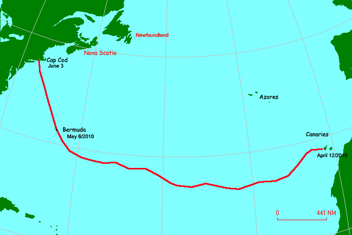 The first four days were hard going. A slow moving low gave strong NW winds. Close hauled with two reefs and half the # 2 Taonui was pushed south. I didn't mind too much as I knew I had to make a looping course to the south to keep away from the North Atlantic High. By April 20 th I was 900 miles from Gomera (28 South) and down to 24 South. The barometer was rising and soon the wind died. As I motored over smooth seas on April 21 there was a BIG BANG and the motor stopped and the rudder was jammed. A look over the side confirmed my worst fear. A huge lump of fishing net was wrapped around the prop and jammed between the prop and the rudder. It took me 1 ½ hours to saw the polyprop net and rope away. The only effective tool was a long serrated galley knife. Some of the net was welded around the prop shaft. I had to cut it away with a chisel and rubber mallet. Thank goodness the sea was calm and the water warm.
 
Three days later I was definitely south of the high and the wind was SE allowing me to set the Asymmetrical Chute giving 5.5 knots of boat speed in only 10 knots of wind. Lovely sailing.
Sadly it didn't last and the wind went back into the SW the next day, and then into the west. For two days I stayed close hauled. I wanted to stay along 27-28 South until I got to 45W in order to keep out of the high. By April 28 I was in steady SSE to SSW winds enjoying some great beam reach to close reach sailing logging 135 150 mile days.
The last week was a grind against the prevailing NW on the west side of the High. The wind was light and the seas 4 5 feet. For 30 hours I tried beating, playing the wind shifts if I could find them, but was only achieving 3.5 knots made good towards Bermuda. So on May 3, I turned on the motor with 360 miles to go to St. George, the harbour at the NE corner of Bermuda and the main entrance into the coral reefs that surround the western and northern sides of the Island. The passage from La Gomera took 24 days and the distance sailed was 2,886 miles. A rather slow passage, but to be expected.
Bermuda
I stayed in St. George for five days carrying out the usual maintenance jobs after an ocean passage. Coryn flew in on May 12 and we moved down to Hamilton Harbour and anchored off Hinton Island where Tony and Liz Jones, the OCC Port Officers for Bermuda, have their home. It was a great base for exploring the Island. We were last in Bermuda in 1980 when we made our first offshore passage in Maistral from the Chesapeake to Bermuda on our way to Ireland.
Bermuda is a tourist destination. It always has been, but in the past thirty years there has been a huge amount of development...gated communities and other uglies. Most days there are two huge cruise ships moored at the Dockyards and twice a week another ship moors in downtown Hamilton. Daily flights from New York, Boston and Toronto bring more tourists and people with holiday condo's and houses. People come for golf, tennis and the beaches and for tourist attractions highlighting the long and colourful history of the Island. We spent a day at the renovated Royal Naval Dockyards. After the loss of it's American colonies, Britain constructed a massive complex of docks, storage yards, buildings and fortifications at the western tip of Bermuda. It even included a huge floating dry-dock that was towed here from Scotland. For 150 years this base supplied and serviced the British Navy (while it ruled the waves) and protected Britain's interests in the Caribbean. The Commissioner's House, on a hill overlooking the Dockyards and with spectacular views over the waters inside the reef that encircles Bermuda, now houses the Bermuda Maritime Museum. It's many high ceilinged rooms display exhibits of the history (and brutality) of the slave trade, antique maps, 19C and 20C maritime paintings, ships models and much more.
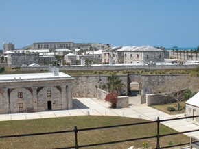  Bermuda to Newport
Bermuda has a well deserved reputation as a colourful, laid back, tourist friendly Island and we thoroughly enjoyed ourselves. But by the end of May it was time to move on.
We headed for Newport, Rhode Island, 620 miles to the NNE with a favourable five day forecast and the prospect of a good lift from the Gulf Stream. A large area of high pressure was making it's way south. We started out in strong east winds on the southern side of the high that gave us a flying broad reach. This only lasted until evening when we reached the centre of the high and had to motor all night. And what a beautiful night, with a full moon and clear skies. By dawn we were into the west wind on the north side of the high and on another broad reach, now on a port tack, eating up the miles in perfect conditions. Fifteen knots of wind, slight seas, though the residual easterly swell was still there to toss us around, one reef in the main, full #1 genoa, making 6.5 knots, sometimes seven.
Two days later we were in the Gulf Stream. Nasty choppy seas, rain, not much wind. Not much fun. Even with full sail we couldn't make more than 2.5 - 3 knots as the waves robbed the wind from the sails. So on with the motor, but even at high rev's speed was down to 4 knots as the seas threw her about.
Gradually the seas subsided and the speed picked up. Slowly a SW wind crept across the ocean and we could start sailing again. And easy sailing it was, smooth seas, no swell. Down below only the gently whispering of bubbles along the hull suggested motion. Great for catching up on sleep. We were keeping a 3 hours on and off watch. There is a lot of shipping in and out of the seaports in the Chesapeake and north up the coast.
On June 2, with only 101 miles to go, we sailed into a different climate. What a contrast. Yesterday HOT. Today damp, cool fog!! Warm air over colder water. We had crossed into the strong cold current that flows down here from Newfoundland and Labrador. It was strong, pushing Taonui 10 - 12 degrees off course. Well I guess something has to replace all that warm Gulf Stream water.
The wind dropped and shifted to the NNW and with it came pea-soup fog. Could only see 1/4 mile at best. To confound matters the area was littered with fishing buoys marked with radar reflector posts. The radar screen was speckled with echos and it was useless to use the radar's "guard" capability, as it was set off by these reflectors as well as by ships. The AIS system, which picks up coded VHF transmissions from all equipped ships (and they all should be so equipped), should alert us to all big ships. But fishing boats, yachts and the like do not usually have a AIS transponder.
Newport
We stayed in Newport for three days replacing the gear box transmission cable which snapped two days ago and cleaning the coil and bushing's of the motor of the auto pilot which was failing during that last few days. And, of course, we did all the touristy things. Newport has a long maritime history and is now a centre for the restoration of old sailing ships and yachts. We made a tour of the harbour in the dinghy to admire the many large yachts that are based here or had come for the bi-annual Newport-Bermuda Race that would start on July 18. On the south side of the harbour, at the top of a vast sloping lawn, is the imposing clubhouse of the New York Yacht Club which for many years hosted the America's Cup Yacht Race. America won the trophy from the British in 1857. They renamed the trophy "the America's Cup" and put it up for challenge every four years. Challengers came from the UK, France, Italy and Australia. The American's were undefeated until the Perth Yacht Club's " Australia II" won in a 3-2 series in 1983. There are still a number of old America's Cup 12 metre yachts in Newport taking tourists out for day trips and a taste of the exhilarating performance of these graceful sleek racing machines.
In the 1890's Newport was the summer social centre for the rich and famous from New York and the southern plantation states. Families such as the Vanderbilts, Astors and the Dukes built "summer cottages", palatial stone mansions decorated in lavish style with furniture and art collected from Europe. The introduction of income and inheritance taxes in the 1930's and the Depression put an end to much of the extravagance, and today some 18 houses are held by several trusts and are open to the public. A casino, built in 1880, for parties and social events, included eight lawn tennis courts. It hosted the first US Lawn Tennis Championship in 1881, the tournament that became the US Open. It now houses the International Tennis Hall of Fame. It was here that the Newport Jazz Festival had it's beginnings.
Over the next two weeks we made our way down East as they say, stopping at Manchester an old shipbuilding and trading port, Isle of Shoals, now the site of a religious retreat, and historic Boothbay Harbor now very touristy. Next was Damariscove, on a rather remote offshore island which is considered to be the first year-round settlement in North America. When the "Mayflower" called here in 1620 to take on a stock of dried-cod, Damariscove was already a major fishing and trading harbour. When the Indian Wars broke out in 1676 many coastal settlers fled to Damariscove to escape the attacks which lasted on and off for fifty years. Today the Island is managed by the Nature Conservancy and all that remains of the 350 year old community are rusted bits of farm implements, building basements and an US Lifeboat Station, seen in the background of the picture.
Some would have it that the best of Maine cruising is east of Camden. It may be so, but our wanderings across Canso Bay over the next two weeks took us through some lovely waterways and to excellent, but often crowded anchorages. The weather was unusually clear and warm, though the 49 mile, eight hour run from Damariscove Island to Camden was in solid fog and drizzle. But what a great sail. Twenty+ knots of wind on a beam reach followed by a wing and wing run when we turned north into Penobscot Bay. Radar and computer mapping make such conditions tolerably safe, but the old fashioned fog horn is still a great way of alerting nearby boats. The biggest problem is lobster boats, so occupied in hauling their pots that they don't seem to pay much heed to other boats. And of course, in shallow water, we had to keep a constant watch for lobster pots. There is much less probability of snagging one while we are under sail and, at speed, Taonui just brushes them aside....at least that's the theory.
Bermuda to Newport
Bermuda has a well deserved reputation as a colourful, laid back, tourist friendly Island and we thoroughly enjoyed ourselves. But by the end of May it was time to move on.
We headed for Newport, Rhode Island, 620 miles to the NNE with a favourable five day forecast and the prospect of a good lift from the Gulf Stream. A large area of high pressure was making it's way south. We started out in strong east winds on the southern side of the high that gave us a flying broad reach. This only lasted until evening when we reached the centre of the high and had to motor all night. And what a beautiful night, with a full moon and clear skies. By dawn we were into the west wind on the north side of the high and on another broad reach, now on a port tack, eating up the miles in perfect conditions. Fifteen knots of wind, slight seas, though the residual easterly swell was still there to toss us around, one reef in the main, full #1 genoa, making 6.5 knots, sometimes seven.
Two days later we were in the Gulf Stream. Nasty choppy seas, rain, not much wind. Not much fun. Even with full sail we couldn't make more than 2.5 - 3 knots as the waves robbed the wind from the sails. So on with the motor, but even at high rev's speed was down to 4 knots as the seas threw her about.
Gradually the seas subsided and the speed picked up. Slowly a SW wind crept across the ocean and we could start sailing again. And easy sailing it was, smooth seas, no swell. Down below only the gently whispering of bubbles along the hull suggested motion. Great for catching up on sleep. We were keeping a 3 hours on and off watch. There is a lot of shipping in and out of the seaports in the Chesapeake and north up the coast.
On June 2, with only 101 miles to go, we sailed into a different climate. What a contrast. Yesterday HOT. Today damp, cool fog!! Warm air over colder water. We had crossed into the strong cold current that flows down here from Newfoundland and Labrador. It was strong, pushing Taonui 10 - 12 degrees off course. Well I guess something has to replace all that warm Gulf Stream water.
The wind dropped and shifted to the NNW and with it came pea-soup fog. Could only see 1/4 mile at best. To confound matters the area was littered with fishing buoys marked with radar reflector posts. The radar screen was speckled with echos and it was useless to use the radar's "guard" capability, as it was set off by these reflectors as well as by ships. The AIS system, which picks up coded VHF transmissions from all equipped ships (and they all should be so equipped), should alert us to all big ships. But fishing boats, yachts and the like do not usually have a AIS transponder.
Newport
We stayed in Newport for three days replacing the gear box transmission cable which snapped two days ago and cleaning the coil and bushing's of the motor of the auto pilot which was failing during that last few days. And, of course, we did all the touristy things. Newport has a long maritime history and is now a centre for the restoration of old sailing ships and yachts. We made a tour of the harbour in the dinghy to admire the many large yachts that are based here or had come for the bi-annual Newport-Bermuda Race that would start on July 18. On the south side of the harbour, at the top of a vast sloping lawn, is the imposing clubhouse of the New York Yacht Club which for many years hosted the America's Cup Yacht Race. America won the trophy from the British in 1857. They renamed the trophy "the America's Cup" and put it up for challenge every four years. Challengers came from the UK, France, Italy and Australia. The American's were undefeated until the Perth Yacht Club's " Australia II" won in a 3-2 series in 1983. There are still a number of old America's Cup 12 metre yachts in Newport taking tourists out for day trips and a taste of the exhilarating performance of these graceful sleek racing machines.
In the 1890's Newport was the summer social centre for the rich and famous from New York and the southern plantation states. Families such as the Vanderbilts, Astors and the Dukes built "summer cottages", palatial stone mansions decorated in lavish style with furniture and art collected from Europe. The introduction of income and inheritance taxes in the 1930's and the Depression put an end to much of the extravagance, and today some 18 houses are held by several trusts and are open to the public. A casino, built in 1880, for parties and social events, included eight lawn tennis courts. It hosted the first US Lawn Tennis Championship in 1881, the tournament that became the US Open. It now houses the International Tennis Hall of Fame. It was here that the Newport Jazz Festival had it's beginnings.
Over the next two weeks we made our way down East as they say, stopping at Manchester an old shipbuilding and trading port, Isle of Shoals, now the site of a religious retreat, and historic Boothbay Harbor now very touristy. Next was Damariscove, on a rather remote offshore island which is considered to be the first year-round settlement in North America. When the "Mayflower" called here in 1620 to take on a stock of dried-cod, Damariscove was already a major fishing and trading harbour. When the Indian Wars broke out in 1676 many coastal settlers fled to Damariscove to escape the attacks which lasted on and off for fifty years. Today the Island is managed by the Nature Conservancy and all that remains of the 350 year old community are rusted bits of farm implements, building basements and an US Lifeboat Station, seen in the background of the picture.
Some would have it that the best of Maine cruising is east of Camden. It may be so, but our wanderings across Canso Bay over the next two weeks took us through some lovely waterways and to excellent, but often crowded anchorages. The weather was unusually clear and warm, though the 49 mile, eight hour run from Damariscove Island to Camden was in solid fog and drizzle. But what a great sail. Twenty+ knots of wind on a beam reach followed by a wing and wing run when we turned north into Penobscot Bay. Radar and computer mapping make such conditions tolerably safe, but the old fashioned fog horn is still a great way of alerting nearby boats. The biggest problem is lobster boats, so occupied in hauling their pots that they don't seem to pay much heed to other boats. And of course, in shallow water, we had to keep a constant watch for lobster pots. There is much less probability of snagging one while we are under sail and, at speed, Taonui just brushes them aside....at least that's the theory.
We stayed almost two weeks in Camden tied to a float at the head of the Inner Harbor. It was as if we had front row seats for a moving pageant of life around this very picturesque tourist port. Our float was the turning point for the old windjammers returning to drop off their passengers on the southern shore. On the northern shore is Wayfarer Marine who were launching boats stored there for the winter. A stream cascading into the sea at the head of the harbour provided constant background music while the bell of a white-spired typically New England church tolled the hours (12 gongs at midnight, count them!!) and at mid-day plays a delicate five minute peel of some old melody. The classically styled library building sited on the hill beside the stream looks down to the harbour over terraced lawns and an amphitheatre where there are nightly concerts. To top it off, the weather was perfect. Warm and clear. Wayfarer Marine carried out some much needed jobs on Taonui. They have a laundry right on the dock, an excellent wifi site that we could access from the boat and a big TV where we could watch some of Wimbledon. What more could we ask for.
They even provided a courtesy car that we could use for shopping and to go to the local airport where we rented a car for three days of exploring some of the interior of Maine, particularly the lake district in the west of the state where we even found an old covered bridge built in 1857.  Leaving Camden we moved slowly across Penobscot Bay and into Jericho Bay. This part of Maine must be one of the more beautiful cruising areas in the world. The bays are deeply indented with numerous large and small wooded islands and intricate passages. The shorelines are typically pale yellowy/grey granite shelves and boulders topped by mature second growth pine forests. The only drawbacks are the FOG and lobster pot floats.
The floats are no real problem when we are under sail, but under motor, particularly in the fog, constant attention is required to avoid wrapping the line to the lobster pot around the prop. The sea is littered with lobster floats, probably one every 100 feet in many areas.
On July 10 we anchored in a pool between Bold and Devil Island, two of the 40 islands in Merchants Row. We came in in fog and drizzle, but the next morning was sparkling sunshine and a light drying West wind. At low tide we were surrounded on three sides by pale white and grey granite shelves and yellow sand bars. We walked around Devil Island on a well maintained private trail through a dense forest interspersed with clearings of bright green new ferns and new growth small pine trees. We had the anchorage to ourselves. The Guide Book's description of Merchants Row concludes with "It may be the most beautiful place in the world."
We stopped at Mount Desert Island for three days. It a favourite tourist area and by mid-summer was rather crowded. The highlight was the Asticou Gardens above Northeast Harbor. They were created in the 1890s by the local innkeeper Charles Savage and designed by the famed landscape artist George Curtis "for the quiet recreation of the people of this town and their summer guests." And what a pleasure they were. Beautifully presented perennial borders, sculptured shrubbery against a background of mature native and imported trees. The gardens have an Oriental feel enhanced by the patterns drawn by rake each morning in the crushed pink granite paths.
On July 20 we reached Mistake Island, our last stop in Maine. We anchored in early afternoon in a pool surrounded by twelve foot high walls of dark seaweed, topped by a strip of pink granite and then 100 foot high pine trees. Six hours later, the tide was high, the dark walls are gone and the granite was glowing in the evening sun. A clear pale blue sky and the only sound is an occasional Bald Eagle call. We were close to the northeast corner of Maine (and the US of A). Its only 50 miles to Canada. Maine got better the further east we came and this last part is quite special. The only villages are inland. There are no houses along the coast. The only evidence of man is lobster pots, lighthouses and navigation buoys. And there are more birds.... osprey, razorbills, Wilson's petrel and, for the first time this trip, puffins hurrying back and forth carrying little fish to their young.
Nova Scotia
The trip across to Shelburne and then up the coast to Halifax was a pleasure. No fog. Broad reaching in N and NW winds, AND, no lobster pots. The season for lobster harvesting was closed. In Canada lobster harvesting is highly regulated and each area has a defined open season. Not so in the US where lobstering goes on all year. On previous visits to Nova Scotia we had sailed with few stops from Halifax to Canso. This time we stopped and explored some of the beautiful remote anchorages along this coast. Particular favourites were Marie and Joseph Harbour and Dogfish Cove. Canso, once a vibrant cod fishing port, is sinking further into obscurity. So sad. Population dwindling. Only the old folks left.
We had a fast sail across the Straits to St. Peters at the entrance to the canal into the Bras D'or Lakes in Cape Breton. Baddeck was still as laid back as ever and a great place to visit, especially the excellent museum describing the life and achievements of Alexander Graham Bell. Coryn flew home from Baddeck and a Newfoundland/Victoria friend, Angus Taylor sailed with me from Baddeck directly to Long Pond in Conception Bay the home of the Royal Newfoundland Yacht Club where Taonui was to spend the winter.
Leaving Camden we moved slowly across Penobscot Bay and into Jericho Bay. This part of Maine must be one of the more beautiful cruising areas in the world. The bays are deeply indented with numerous large and small wooded islands and intricate passages. The shorelines are typically pale yellowy/grey granite shelves and boulders topped by mature second growth pine forests. The only drawbacks are the FOG and lobster pot floats.
The floats are no real problem when we are under sail, but under motor, particularly in the fog, constant attention is required to avoid wrapping the line to the lobster pot around the prop. The sea is littered with lobster floats, probably one every 100 feet in many areas.
On July 10 we anchored in a pool between Bold and Devil Island, two of the 40 islands in Merchants Row. We came in in fog and drizzle, but the next morning was sparkling sunshine and a light drying West wind. At low tide we were surrounded on three sides by pale white and grey granite shelves and yellow sand bars. We walked around Devil Island on a well maintained private trail through a dense forest interspersed with clearings of bright green new ferns and new growth small pine trees. We had the anchorage to ourselves. The Guide Book's description of Merchants Row concludes with "It may be the most beautiful place in the world."
We stopped at Mount Desert Island for three days. It a favourite tourist area and by mid-summer was rather crowded. The highlight was the Asticou Gardens above Northeast Harbor. They were created in the 1890s by the local innkeeper Charles Savage and designed by the famed landscape artist George Curtis "for the quiet recreation of the people of this town and their summer guests." And what a pleasure they were. Beautifully presented perennial borders, sculptured shrubbery against a background of mature native and imported trees. The gardens have an Oriental feel enhanced by the patterns drawn by rake each morning in the crushed pink granite paths.
On July 20 we reached Mistake Island, our last stop in Maine. We anchored in early afternoon in a pool surrounded by twelve foot high walls of dark seaweed, topped by a strip of pink granite and then 100 foot high pine trees. Six hours later, the tide was high, the dark walls are gone and the granite was glowing in the evening sun. A clear pale blue sky and the only sound is an occasional Bald Eagle call. We were close to the northeast corner of Maine (and the US of A). Its only 50 miles to Canada. Maine got better the further east we came and this last part is quite special. The only villages are inland. There are no houses along the coast. The only evidence of man is lobster pots, lighthouses and navigation buoys. And there are more birds.... osprey, razorbills, Wilson's petrel and, for the first time this trip, puffins hurrying back and forth carrying little fish to their young.
Nova Scotia
The trip across to Shelburne and then up the coast to Halifax was a pleasure. No fog. Broad reaching in N and NW winds, AND, no lobster pots. The season for lobster harvesting was closed. In Canada lobster harvesting is highly regulated and each area has a defined open season. Not so in the US where lobstering goes on all year. On previous visits to Nova Scotia we had sailed with few stops from Halifax to Canso. This time we stopped and explored some of the beautiful remote anchorages along this coast. Particular favourites were Marie and Joseph Harbour and Dogfish Cove. Canso, once a vibrant cod fishing port, is sinking further into obscurity. So sad. Population dwindling. Only the old folks left.
We had a fast sail across the Straits to St. Peters at the entrance to the canal into the Bras D'or Lakes in Cape Breton. Baddeck was still as laid back as ever and a great place to visit, especially the excellent museum describing the life and achievements of Alexander Graham Bell. Coryn flew home from Baddeck and a Newfoundland/Victoria friend, Angus Taylor sailed with me from Baddeck directly to Long Pond in Conception Bay the home of the Royal Newfoundland Yacht Club where Taonui was to spend the winter.
2011 Newfoundland, Labrador and Scotland
It took two weeks to get Taonui back in the water and ready to go. Four days went on a thorough sanding of the bottom in preparation for three coats of a new envioronmementally friendly antifouling paint. Getting the mast "dressed", lifted and secured took another two days. On June 8 we started along the NE coast of Newfoundalnd stopping at Old Perlican, Catalina, the Flat Islands and Seldom Come By, the full name of which is Seldom Come By Without Stopping. And no wonder. The excellent well-sheltered harbour is on the direct route along the coast and was a must-stop for the schooners on their annual passage to the Labrador fishing grounds.We tied to the dock that is part of a small Visitor's Centre created by the Fogo municipality using two hundred year old buildings that were once a Co-Op store and a salt storage and cod liver oil factory. All this is now a museum showcasing the history of the local fishing industry and particularly the Fogo Fisherman's Co-Op. In the 1950's/60's there was a serious decline in the cod stocks around Fogo Island causing many of the local fishermen to quit fishing. The then Premier, Joey Smallwood, came along with his idea of resettling the Newfoundland outports. Many outports elected to fold, but the Fogo Islanders elected to stay. They formed a Co-op, obtained a loan from the bank and built a shipyard and in 1968 launched 4 (of 30)longliners capable of offshore work. Today the island has crab, fish and shrimp plants and all still going strong
 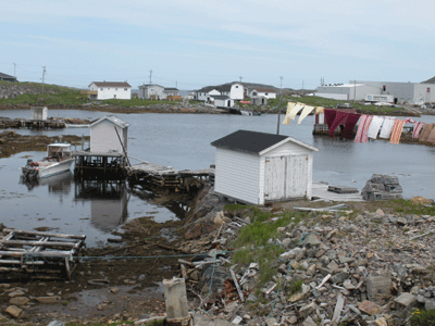 Visitors Docks at Seldom
The Visitor's Centre shows the enterprise of the Fogo islanders. Great facilities for passing yachts....an excellent dock, showers, washing machines. The manager lent us a huge truck to drive to the supermarket in the middle of the Island and go to the nearby library/internet access centre. We drove around the Island visiting the communities on the north side. Of particular interest are the artist's retreats created by local born, now returned high-powered businesswoman Zita Cobb. Todd is from Gander, but now practices in Norway. We saw two of the retreats, both stunning black 'salt boxes' stuck out in the middle of the rocky barren countryside overlooking some wild waters. You can read more about Zita Cobb and Todd Saunders here
Visitors Docks at Seldom
The Visitor's Centre shows the enterprise of the Fogo islanders. Great facilities for passing yachts....an excellent dock, showers, washing machines. The manager lent us a huge truck to drive to the supermarket in the middle of the Island and go to the nearby library/internet access centre. We drove around the Island visiting the communities on the north side. Of particular interest are the artist's retreats created by local born, now returned high-powered businesswoman Zita Cobb. Todd is from Gander, but now practices in Norway. We saw two of the retreats, both stunning black 'salt boxes' stuck out in the middle of the rocky barren countryside overlooking some wild waters. You can read more about Zita Cobb and Todd Saunders here |
  Joe Batts Arm, North side Fogo Island
We had a great 35 mile passage from Seldom, north past the Change Islands and then south to Puzzle Harbour one of the "must stop" anchorages in eastern Notre Dame Bay. Excellent shelter from low rolling hills and only a couple of colourful cabins to be seen along the shoreline. We had stayed there before and enjoyed several days of hiking and berry picking. Not this time. It was cold and driving rain. Our next stop was Lewisporte where we sheltered for four days in the marina, while outside it blew hard from the NE gradually shifting to the NW. The Yacht Club made us welcome as were the hot showers and a laundry. Yesterday we motored upwind to Sivier Island for a change of scenery. Thank goodness for the Refleks diesel heater that keeps us warm and snug down below...reading, crosswords, suduko's etc.
Joe Batts Arm, North side Fogo Island
We had a great 35 mile passage from Seldom, north past the Change Islands and then south to Puzzle Harbour one of the "must stop" anchorages in eastern Notre Dame Bay. Excellent shelter from low rolling hills and only a couple of colourful cabins to be seen along the shoreline. We had stayed there before and enjoyed several days of hiking and berry picking. Not this time. It was cold and driving rain. Our next stop was Lewisporte where we sheltered for four days in the marina, while outside it blew hard from the NE gradually shifting to the NW. The Yacht Club made us welcome as were the hot showers and a laundry. Yesterday we motored upwind to Sivier Island for a change of scenery. Thank goodness for the Refleks diesel heater that keeps us warm and snug down below...reading, crosswords, suduko's etc.
 By late June the weather turned to summer giving us easy sailing as we moved on across Notre Dame Bay stopping at Exploits, Little Bay Islands, Round Harbour and Fourche Harbour where we dug our way into
Williamsport,a remote long abandoned outport in a small bay within Forche Harbour. Although it is on the mainland there is no road to Williamsport or to any of the bays to the south of here along the east side of the Northern Peninsular. This is a coast of high (1,500 ft.) mountains and deep fiords. It lacks the small offshore islands and ledges that are favoured by breeding cod so it never did attract many fishermen. Williamsport looks to have had only about 15 houses. A whaling station operated further up the fiord for some years, closing in 1972. At the head of the bay is a rather poignant cemetery, particularly in the drizzle and mist, with a dozen stones dating from 1930. The last being placed in 1962. Two side by side stones marked the graves of two brothers, 20 and 24, drowned.
By late June the weather turned to summer giving us easy sailing as we moved on across Notre Dame Bay stopping at Exploits, Little Bay Islands, Round Harbour and Fourche Harbour where we dug our way into
Williamsport,a remote long abandoned outport in a small bay within Forche Harbour. Although it is on the mainland there is no road to Williamsport or to any of the bays to the south of here along the east side of the Northern Peninsular. This is a coast of high (1,500 ft.) mountains and deep fiords. It lacks the small offshore islands and ledges that are favoured by breeding cod so it never did attract many fishermen. Williamsport looks to have had only about 15 houses. A whaling station operated further up the fiord for some years, closing in 1972. At the head of the bay is a rather poignant cemetery, particularly in the drizzle and mist, with a dozen stones dating from 1930. The last being placed in 1962. Two side by side stones marked the graves of two brothers, 20 and 24, drowned.
We reached St. Anthony at the end of June and after stocking up with food, water and diesel headed north to Labrador on July 5. That evening we were motoring in calm seas about 50 miles out of St. Anthony on the northern side of the Belle Isle Strait when there was a bit of a bang and a rattling sound and the boat slowed to a stop. The engine was still running smoothly but no power was going to the prop. Somewhere aft of the engine something had become disconnected. Nothing for it but to sail back to St. Anthony. We called the Coast Guard to tell them of our predicament and they alerted shipping in the Strait of Belle Isle. With no wind, we drifted at .8 knot carried south on the Labrador Current. It was a long cold night. By mid morning a breeze had built from the west and were making good progress. The St. Anthony Harbour Master met us at the entrance and towed us against the wind up the narrow inner passage to the harbour and parked us against the western end of the main dock.
We had to spend seven days in St. Anthony grinding against dock as the wind blew hard from the NE and NW. On Tuesday the parts arrived to replace the coupling between the engine and the gear box. Unfortunately the two metal parts were the wrong size (even though they had the same part number), so we had to install the key component, the rubber element, using the old metal parts, which though damaged should still function. Or so we hoped.
We set out again on July 14 and had a lovely broad reach all the way to Horne Bay in Niger Sound, to the north of Battle Harbour. That night was one of those warm summer's evening that seem special to Labrador. Loons calling all night. A sky full of stars.
The next day we had a bouncy downwind sail against the current and a nasty swell/chop from the north for 35 miles to Ship Harbour where we stayed for a few days enjoying some great hiking.
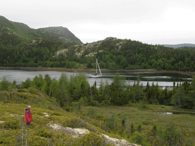  After stops at American Tickle and Bateau Harbour we set off for a long 60 mile haul to Cartwright, but after four hours of motoring the transmission failed again. We kept sailing but it was clear that without a tow we would not get in before dark. The weather forecast was not good and sailing in the dark amongst islands and ice was not a good idea. The Coast Guard arranged for a fishing boat, the Crystal Sea to met us and tow us the last four hours into Cartwright. A more extensive dismantling of the connection between the engine and the gear box showed that the problem was that a collar that should have held one of the coupling plates in place had slipped, allowing the plates to separate and the rubber element between to come free and disintegrate. We had to wait two weeks to get new parts shipped from Denmark. ( The Bukh factory was closed in late July for summer's holidays).
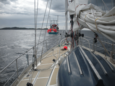 Taonui under tow by the Crystal Sea
It was clear that we had run out of time to get to Cape Chidley and back to Lewisporte, where we had palnned to leave Taonui for the winter. Coryn had not been feeling well for a month or more. So we decided that I would take Taonui over to Scotland and Coryn would fly back to Victoria. I had been planning to cross the Atlantic next spring so why not do it now when the weather is better. It was a good thing that Coryn went home. Later she was diagnosed with endocarditis, an infection on her replaced aorta valve. The infection was carried to her lower back and she ended up in hospital for 37 days!!!.
Taonui under tow by the Crystal Sea
It was clear that we had run out of time to get to Cape Chidley and back to Lewisporte, where we had palnned to leave Taonui for the winter. Coryn had not been feeling well for a month or more. So we decided that I would take Taonui over to Scotland and Coryn would fly back to Victoria. I had been planning to cross the Atlantic next spring so why not do it now when the weather is better. It was a good thing that Coryn went home. Later she was diagnosed with endocarditis, an infection on her replaced aorta valve. The infection was carried to her lower back and she ended up in hospital for 37 days!!!.
 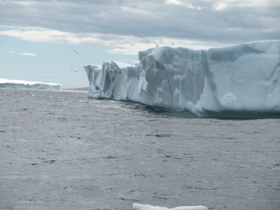 Grounded Ice Island near American Tickle, part of the 350 square kilometer piece of the Peterman glacier that had drifted north and then south on the Labrador Current.
Labrador to Barra, Scotland
August 4, 2011. Coryn was picked up at 9 AM on Wednesday for a long 5 hour drive to Goose Bay(that turned out to be 7 hours)and after waiting two days flew back to Victoria today via Halifax and Toronto.
The long awaited parts arrived yesterday and with some huffing and puffing the gear box was reconnected to the engine by mid-afternoon. I left at 06:00 Thursday morning. Perfect weather. Rising barometer, SE 20 + knots, veering S tonight. Three reefs in main and 2/3 #2 genoa making 7.5 - 8 knots on close reach. Taonui loved it and it was a pleasure to be at sea again. Made 34 miles to noon, leaving 1,636 miles to go to Barra, Outer Isles of Scotland.
August 5. Had a great run of 162 miles noon-to-noon, as the wind stayed in the south blowing up the west side of a ridge. And, importantly, no fog and no ice. This was a big factor in our decision that I should sail across to Scotland this year rather than wait until the spring of next year. The disintegrating ice islands from the Peterman Glacier have all drifted south and the waters north of 55 N are reportedly ice free. Just in case there is a stray one still about the radar comes on every 20 minutes and scans over a 12 mile guard-zone. I wish that I could stay in this high pressure ridge for ever but it isn't going to happen. There is a deepening low coming north from Cape Cod that will hit Newfoundland with forecast 45 knots late tonight. I can expect NE 30+ starting tomorrow morning and that wind is forecast to hold for two days before backing to the North.
But that's for tomorrow. Right now, 16:00, the sun is warm, the wind is 15 knots on the beam,stiff-winged Fulmars are wheeling over the white caps while Taonui eats up the miles on a wonderful day to be out on a wide ocean.
August 6, 2011. A good run for the day, noon-to-noon 149 miles in a southerly wind. Early afternoon the wind quit so on with the motor. Two hours later a light east wind was making little waves. The low that has been hammering the east coast of Newfoundland has drifted east from the Grand Banks but will turn north east...they usually do. Oh well, not much I can do about. If I go north I'll just stay in it longer. If I take the port tack I'll go right through the middle of it and out into SE winds that will eventually turn S and then SW.... at least that's the theory. Its going to be a big drop in the barograph which is now 1025. The low is 994. Lots of wind coming.
For the next three days Taonui was hard on the wind as the low slowly drifted NE. With 30+ knots Taonui was down to three reefs and the orange staysail, jogging along, making 4 knots, Albert doing great job of keeping her on the wind.
Grounded Ice Island near American Tickle, part of the 350 square kilometer piece of the Peterman glacier that had drifted north and then south on the Labrador Current.
Labrador to Barra, Scotland
August 4, 2011. Coryn was picked up at 9 AM on Wednesday for a long 5 hour drive to Goose Bay(that turned out to be 7 hours)and after waiting two days flew back to Victoria today via Halifax and Toronto.
The long awaited parts arrived yesterday and with some huffing and puffing the gear box was reconnected to the engine by mid-afternoon. I left at 06:00 Thursday morning. Perfect weather. Rising barometer, SE 20 + knots, veering S tonight. Three reefs in main and 2/3 #2 genoa making 7.5 - 8 knots on close reach. Taonui loved it and it was a pleasure to be at sea again. Made 34 miles to noon, leaving 1,636 miles to go to Barra, Outer Isles of Scotland.
August 5. Had a great run of 162 miles noon-to-noon, as the wind stayed in the south blowing up the west side of a ridge. And, importantly, no fog and no ice. This was a big factor in our decision that I should sail across to Scotland this year rather than wait until the spring of next year. The disintegrating ice islands from the Peterman Glacier have all drifted south and the waters north of 55 N are reportedly ice free. Just in case there is a stray one still about the radar comes on every 20 minutes and scans over a 12 mile guard-zone. I wish that I could stay in this high pressure ridge for ever but it isn't going to happen. There is a deepening low coming north from Cape Cod that will hit Newfoundland with forecast 45 knots late tonight. I can expect NE 30+ starting tomorrow morning and that wind is forecast to hold for two days before backing to the North.
But that's for tomorrow. Right now, 16:00, the sun is warm, the wind is 15 knots on the beam,stiff-winged Fulmars are wheeling over the white caps while Taonui eats up the miles on a wonderful day to be out on a wide ocean.
August 6, 2011. A good run for the day, noon-to-noon 149 miles in a southerly wind. Early afternoon the wind quit so on with the motor. Two hours later a light east wind was making little waves. The low that has been hammering the east coast of Newfoundland has drifted east from the Grand Banks but will turn north east...they usually do. Oh well, not much I can do about. If I go north I'll just stay in it longer. If I take the port tack I'll go right through the middle of it and out into SE winds that will eventually turn S and then SW.... at least that's the theory. Its going to be a big drop in the barograph which is now 1025. The low is 994. Lots of wind coming.
For the next three days Taonui was hard on the wind as the low slowly drifted NE. With 30+ knots Taonui was down to three reefs and the orange staysail, jogging along, making 4 knots, Albert doing great job of keeping her on the wind.
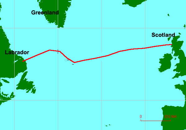 August 10, 2011. The barograph has bottomed out and the wind has dropped to 15 - 20 knots and backed to the NNE. I can just about lay the required course of 85M. Thank goodness that's over. I'm now back at the latitude of Cartwright. After getting north to 56N in the first three days,the last three days of bashing into the East winds of the low have pushed Taonui back south. Since leaving Cartwright I've only made good 570 miles towards Barra, an average of 108 miles a day for 6.25 days. Wouldn't mind if was just slow sailing but close hauled for three days into 30 + knots is no fun. Must say that Taonui doesn't seem to mind it. Last night she bashed her way up and over the big waves making steady work of the gale force 35 knots. Three reefs in the main and the staysail. Great combination. Great boat. 1,100 miles to go to Barra.
Over the next two days the wind settled into the SW, the seas subsided and the daily run increased to 145 - 150 miles. Ocean sailing at its best. Taonui ate up the miles and on August 17 th we arrived in Barra in the Outer Hebrides. 13.25 days, 1,788 miles at an average 135 miles a day.
The next day with a favourable tide and a following wind I made an 80 mile run across the Minch and down the Sound of Mull to Oban where Taonui was to spend the winter.
August 10, 2011. The barograph has bottomed out and the wind has dropped to 15 - 20 knots and backed to the NNE. I can just about lay the required course of 85M. Thank goodness that's over. I'm now back at the latitude of Cartwright. After getting north to 56N in the first three days,the last three days of bashing into the East winds of the low have pushed Taonui back south. Since leaving Cartwright I've only made good 570 miles towards Barra, an average of 108 miles a day for 6.25 days. Wouldn't mind if was just slow sailing but close hauled for three days into 30 + knots is no fun. Must say that Taonui doesn't seem to mind it. Last night she bashed her way up and over the big waves making steady work of the gale force 35 knots. Three reefs in the main and the staysail. Great combination. Great boat. 1,100 miles to go to Barra.
Over the next two days the wind settled into the SW, the seas subsided and the daily run increased to 145 - 150 miles. Ocean sailing at its best. Taonui ate up the miles and on August 17 th we arrived in Barra in the Outer Hebrides. 13.25 days, 1,788 miles at an average 135 miles a day.
The next day with a favourable tide and a following wind I made an 80 mile run across the Minch and down the Sound of Mull to Oban where Taonui was to spend the winter.
2012 Scotland, Orkneys, Shetlands, Norway and Azores
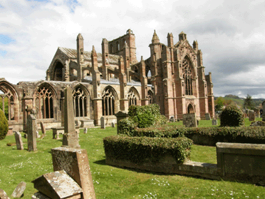 After the winter on the hard at Kerrera Marina in Oban, Taonui was launched April 19th, and I spent the next two weeks getting her ready to go cruising. Coryn arrived May 3rd, and several days later we took the bus to Edinburgh. After two days of sightseeing including an afternoon at the excellent National Museum, we rented a car and headed for the Border country. Rolling hills covered in newly sprouted wheat, barley and the distinctly yellow rape, make this one of the scenic must-see areas of Scotland. The ruins of the magnificent abbeys built in the area from 1200 to 1500 attracts thousands of tourists every year.
By the time we got back to Oban, summer seemed to have arrived in Scotland. We left Oban on May 16 with a favourable tide to carry Taonui up the Sound of Mull and an easy downwind 25 mile run to Tobermory. Just as touristy as ever, Tobermory is a must stop for any boats heading north - a well sheltered bay with colourful houses along the shore. The next day we carried the tide around the much respected Ardnamurchan Point and then north west to Arisaig. Tradition has it that a yacht that has rounded Ardnamurchan should tie a bunch of heather on its pulpit to show it's good fortune or good luck in making a safe passage.
Arisaig is captivating, and we stayed three nights. Each day we went for a long ramble through the surrounding farm lands and forests. Arisaig was closed off during WWII and became a centre for training of secret agents and saboteurs who were sent to France and other occupied countries to create havoc for the Germans. The little visitors centre, cum-museum, has an interesting photo record of the training and bio's of many of the agents. On the harbour front is a rather moving memorial to about 50 Czech's who were trained here who subsequently were captured and executed by the Germans.
From Arisaig we sailed (and motored) through the Small Isles, going south of Eigg, with it's striking volcanic plug on the southern side, then south of Rhum the largest of the Small Isles, about 8 miles by 7 miles. The whole Island is now a nature reserve and visitors are restricted to a small area at the head of a bay on it's eastern side. The rest of the mountainous island is given over to the preservation of the resident herd of Red Deer and Sea Eagles that were once common in the Western Isles but almost became extinct 20 years ago. The eagles on Rhum were imported from Norway.
The weather in late May continued to amaze. 30C, high pressure, clear skies and light winds. Most unusual!! On May 27 we back-tracked to the mainland, to Inverie on the Knoydart Peninsular. This remote area can only be reached by a five mile boat trip from Mallaig or by a 20 mile hike through the mountains. Until 1999 it was owned by a succession of clan chiefs and then by southern "wealthies" who used it as a hunting and fishing retreat. Population peaked at around 2,000 in the 1850's before the "Clearances" to make space for sheep. By 1999 population of Inverie was down to 84 people. They, with help from outsiders led by Chris Brasher (Olympic runner) raised the funds to purchase the land and set it aside as a Wilderness Preserve. Some old buildings have been restored as bunk-houses and a camping area developed. Each year Knoydart attracts a growing number of hikers and climbers. (There are three Munros on the Peninsular). It is a popular stop for cruising yachts. After the winter on the hard at Kerrera Marina in Oban, Taonui was launched April 19th, and I spent the next two weeks getting her ready to go cruising. Coryn arrived May 3rd, and several days later we took the bus to Edinburgh. After two days of sightseeing including an afternoon at the excellent National Museum, we rented a car and headed for the Border country. Rolling hills covered in newly sprouted wheat, barley and the distinctly yellow rape, make this one of the scenic must-see areas of Scotland. The ruins of the magnificent abbeys built in the area from 1200 to 1500 attracts thousands of tourists every year.
By the time we got back to Oban, summer seemed to have arrived in Scotland. We left Oban on May 16 with a favourable tide to carry Taonui up the Sound of Mull and an easy downwind 25 mile run to Tobermory. Just as touristy as ever, Tobermory is a must stop for any boats heading north - a well sheltered bay with colourful houses along the shore. The next day we carried the tide around the much respected Ardnamurchan Point and then north west to Arisaig. Tradition has it that a yacht that has rounded Ardnamurchan should tie a bunch of heather on its pulpit to show it's good fortune or good luck in making a safe passage.
Arisaig is captivating, and we stayed three nights. Each day we went for a long ramble through the surrounding farm lands and forests. Arisaig was closed off during WWII and became a centre for training of secret agents and saboteurs who were sent to France and other occupied countries to create havoc for the Germans. The little visitors centre, cum-museum, has an interesting photo record of the training and bio's of many of the agents. On the harbour front is a rather moving memorial to about 50 Czech's who were trained here who subsequently were captured and executed by the Germans.
From Arisaig we sailed (and motored) through the Small Isles, going south of Eigg, with it's striking volcanic plug on the southern side, then south of Rhum the largest of the Small Isles, about 8 miles by 7 miles. The whole Island is now a nature reserve and visitors are restricted to a small area at the head of a bay on it's eastern side. The rest of the mountainous island is given over to the preservation of the resident herd of Red Deer and Sea Eagles that were once common in the Western Isles but almost became extinct 20 years ago. The eagles on Rhum were imported from Norway.
The weather in late May continued to amaze. 30C, high pressure, clear skies and light winds. Most unusual!! On May 27 we back-tracked to the mainland, to Inverie on the Knoydart Peninsular. This remote area can only be reached by a five mile boat trip from Mallaig or by a 20 mile hike through the mountains. Until 1999 it was owned by a succession of clan chiefs and then by southern "wealthies" who used it as a hunting and fishing retreat. Population peaked at around 2,000 in the 1850's before the "Clearances" to make space for sheep. By 1999 population of Inverie was down to 84 people. They, with help from outsiders led by Chris Brasher (Olympic runner) raised the funds to purchase the land and set it aside as a Wilderness Preserve. Some old buildings have been restored as bunk-houses and a camping area developed. Each year Knoydart attracts a growing number of hikers and climbers. (There are three Munros on the Peninsular). It is a popular stop for cruising yachts.
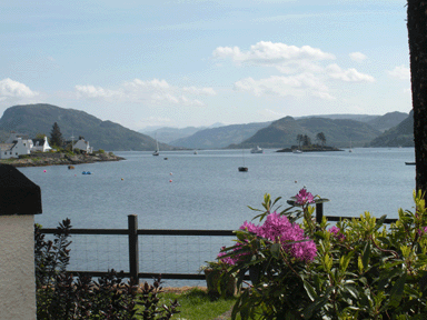 Our next stop was Plockton by way of the Kyle of Lochalsh where the tide runs up to 8 knots through the narrows that are now spanned by a high-level bridge joining Skye to the Mainland. Plockton was once a vibrant fishing port but is now a favourite lunch-stop for tour buses doing day trips out of Glasgow. The bay is ringed by brightly painted row houses many with their own garden running down to the water on the opposite side of the road. Gardening seemed to be something of a competitive sport and garden tours were popular.
Portree is the major town on Skye. Although the anchorage is a bit exposed and subject to strong southerly and westerly winds rushing down from the mountain, it is a great place for topping up supplies and water, and doing a laundry at the Youth Hostel before moving 10 miles up the Sound of Raasay to Acairseid Mor reputed to be one of the most beautiful anchorages in Scotland. Completely landlocked and surrounded by mixed forests and low hills. We have been here three times on past trips and always enjoyed hiking in the surrounding hills.
By June I we were in Ullapool. The high pressure continued, the wind stayed in the NE giving dry clear days. Not so in southern England. It rained on the magnificent Thames River pageant which we watched on a big screen TV in a warm sunny pub in Ullapool along with a happy crowd there to drink it all in, and especially to cheer on their own Ullapool four man gig that had gone down (by road) to row in the 1,000 boat flotilla. Ullapool is a friendly place full of interesting welcoming people. Many are not from here but are attracted by the lifestyle....lots of community activities, two excellent book shops, great access to wilderness areas including the nearby Summer Isles which must be one of the best kayaking locations in the UK. Winding waterways, big tide range (12 feet), many sandy beaches.
After stopping in Loch Laxford to visit old friends, Marie Christine and John Ridgway, we made a 105 mile overnight passage around Cape Wrath and on to Kirkwall, the main town in the Orkney Islands.
Our next stop was Plockton by way of the Kyle of Lochalsh where the tide runs up to 8 knots through the narrows that are now spanned by a high-level bridge joining Skye to the Mainland. Plockton was once a vibrant fishing port but is now a favourite lunch-stop for tour buses doing day trips out of Glasgow. The bay is ringed by brightly painted row houses many with their own garden running down to the water on the opposite side of the road. Gardening seemed to be something of a competitive sport and garden tours were popular.
Portree is the major town on Skye. Although the anchorage is a bit exposed and subject to strong southerly and westerly winds rushing down from the mountain, it is a great place for topping up supplies and water, and doing a laundry at the Youth Hostel before moving 10 miles up the Sound of Raasay to Acairseid Mor reputed to be one of the most beautiful anchorages in Scotland. Completely landlocked and surrounded by mixed forests and low hills. We have been here three times on past trips and always enjoyed hiking in the surrounding hills.
By June I we were in Ullapool. The high pressure continued, the wind stayed in the NE giving dry clear days. Not so in southern England. It rained on the magnificent Thames River pageant which we watched on a big screen TV in a warm sunny pub in Ullapool along with a happy crowd there to drink it all in, and especially to cheer on their own Ullapool four man gig that had gone down (by road) to row in the 1,000 boat flotilla. Ullapool is a friendly place full of interesting welcoming people. Many are not from here but are attracted by the lifestyle....lots of community activities, two excellent book shops, great access to wilderness areas including the nearby Summer Isles which must be one of the best kayaking locations in the UK. Winding waterways, big tide range (12 feet), many sandy beaches.
After stopping in Loch Laxford to visit old friends, Marie Christine and John Ridgway, we made a 105 mile overnight passage around Cape Wrath and on to Kirkwall, the main town in the Orkney Islands.  The new marina in Kirkwall was a great place to leave Taonui while we visited the famous archeological sites... Maeshowe, a Neolithic burial mound, Skara Brae, a 5,000 year old housing cluster built of stone with sod roofs, and the standing stones at the Ring of Brodgar. The St. Magnus Cathedral in Kirkwall, built in the 1200's dominates the town. Attached to it is an excellent museum with fascinating informative displays of local history from Neolithic times to the 1950's.
Across the Bay from Kirkwall is the beautiful Island of Shapinsay where we spent three days roaming around the pristine beaches and over the rolling farm lands before moving north to Sanday one of the richest agricultural islands in the Orkneys. It is also the richest in terms of archaeology with many sites from 6000 years ago through to Viking times. One that we visited was the burial site of a Viking longship discovered in 1991 complete with three skeletons and a trove of jewelry and an iron sword.
We had to make a carefully timed passage north through the 3/4 mile wide Sound between Sanday and Eday and on to Pierowall Harbour on Westray. The tide races through the Orkneys and although we thought that we would be in the narrows at relative slack water we ended up shooting through at 10 knots. An energy company is in the process of testing various sites around the islands for the installation of tide driven power generation. Wind farms are a common site around the Orkneys and no wonder.... rolling hills to create uplift and it's always windy. They are more common in the Shetlands where there is even more wind and steeper hills.
Westray is probably the most dynamic of the Orkney Islands. Population about six hundred. Productive cattle and sheep farms, an offshore crab fishing fleet with a processing factory at Pierowall, several excellent craft shops selling their fine wool/silk/cotton clothing over the internet, a major salmon farming operation based in Pierowall that provides well paying work for young men, an offshore trawler that lands it's catch for processing in the town and distribution throughout the Orkneys and, finally, a bakery that supplies bread, biscuits throughout the Orkneys and often to Lerwick and mainland Scotland. The UK suffers from being a welfare state, but in these Islands and the Shetlands, the work ethic and sense of enterprise is alive and kicking.
We had some great walks on Westray while we waited for a change from the northeast wind. On one hike to the north shore we came across rows and rows of low (3 foot) stone walls. Later we found out that they were used in the late 1880's to dry seaweed which was exported to the UK for the manufacture of a variety of products including explosives, perfume, soaps and more. It was a major source of revenue for the governing Lairds of the Islands.
On June 24 we made the 65 mile passage from Sanday in the northern Orkneys to St. Ninians Bay on the southwestern end of the Sumburgh Peninsular in the Shetlands. A cold and rough trip, hard on the wind the whole way, in a Force 4 - 5 northerly wind. But what a spectacular place to anchor. A mile wide bay, steep cliffs dotted with nesting birds, grass covered slopes to the east and west and a bright yellow scimitar sand beach at the head. From there we motor-sailed against the north wind 15 miles up the Peninsular to the old town of Scalloway set at the end of a winding passage between islands. Scalloway was once the capital of the Shetlands as evidenced by the massive fortified 16 century castle at the head of the harbour.
There is a recently refurbished museum in Scalloway telling the history of the fishing booms in herring, then cod followed by haddock. All that is now history and there is now only one trawler working out of the port. Much of the museum is devoted to the dramatic WWII exploits of The Shetland Bus. When Germany invaded Norway in 1942 many Norwegians escaped in fishing boats and most headed for the Shetlands. Over the next three years Norwegian sailors took fishing boats to Norway from Scalloway loaded with small arms, sabotage experts and radios. On the return trip they brought out refugees fleeing the Gestapo. The Norwegian Resistance tied up twelve battalions of Germans as Hitler become more convinced that England intended to launch an offensive in Norway. The Resistance blew up the German heavy water plant and put an end to German's development of an atomic bomb. To avoid German surveillance most of the to and fro traffic was in the winter months and many lives were lost to the fierce winter storms of the Norwegian Sea.
On June 28 we had to get out of Scalloway to find shelter from a forecast gale from the east blowing into a 984 low. We shot over to the key-hole harbour at Skeld, only 5 miles away, and rode it out. Two days later we sailed north and west to the remote Island of Papa Stour (Island of Priests). Viking history recounts that there were Celtic monks there in the 6th Century. If so, they must have been a hardy lot. Even the sheep had to lean sideways to stay upright in the wind on the western side. The next day we sailed around the wild western side of the island where the constant pounding of the North Atlantic waves on the 200ft+ high cliffs has created an amazing display of arches, caves and stacks. The wind was 15 knots from the NW and the swells had been building for several days, so the whole scene was one of unrelenting force - crashing waves, white spray against black cliffs, deeply troubled waters and, above, wheeling birds, pure whites and blacks against the blue sky. The flood tide was against us, but soon it changed and we carried the ebb up the coast and around the north end of Mainland Shetland Island. Great sailing. Close reach, small genoa, and two reefs, but it was a long, tiring though memorable day and a relief to get onto the leeside of the Island and into a quiet anchorage.
The next day we took advantage of the morning flood tide to run down the Sound of Yell where the tide can run up to 7 knots between the scattering of islands and reefs. Around the Shetlands you have to go with the tide. Sometimes it can run at 7 knots at "springs" and the overfalls at headlands etc. can be awful. The Sound is well marked and charted as it is the route for tanker traffic taking oil in and out of Sullom Voe Oil Terminal which is the landing point of a pipeline from the North Sea Piper Oil field. At times we were making over 10 knots over the ground even though all we had up was the small genoa with the wind behind us.
From Burra Voe at the south end of the Island of Yell it was a tough slog north to Baltasound at the north end of Unst, the northernmost of the Shetland Islands. We miss-timed the tide and left too early in the morning so the first 5 hours were a bash against the tide making only 3 knots over the ground into steep short seas. Once around the eastern corner of Yell we could lay off, the tide turned, the seas smoothed out and we had a fast sail the last 15 miles to Baltasound. In the late 1800's the summer population of Balta would increase by 8,000 people who came to catch and process herring. There is still a thriving farming community and until 2006 a large number of personnel employed at the RAF station at nearby Haroldswick guarding the Northern Approaches to the U.K.
Norway
A change of weather and E - SE winds brought thick fog and we looked liked being stuck in Baltasound for a week or more. From here we were heading due east to Norway. The early July 5 forecast called for very light east winds, backing NE, then north. Too good to pass up, so we left in thick fog which stayed with us for 80 miles while we motored across smooth seas. The new marina in Kirkwall was a great place to leave Taonui while we visited the famous archeological sites... Maeshowe, a Neolithic burial mound, Skara Brae, a 5,000 year old housing cluster built of stone with sod roofs, and the standing stones at the Ring of Brodgar. The St. Magnus Cathedral in Kirkwall, built in the 1200's dominates the town. Attached to it is an excellent museum with fascinating informative displays of local history from Neolithic times to the 1950's.
Across the Bay from Kirkwall is the beautiful Island of Shapinsay where we spent three days roaming around the pristine beaches and over the rolling farm lands before moving north to Sanday one of the richest agricultural islands in the Orkneys. It is also the richest in terms of archaeology with many sites from 6000 years ago through to Viking times. One that we visited was the burial site of a Viking longship discovered in 1991 complete with three skeletons and a trove of jewelry and an iron sword.
We had to make a carefully timed passage north through the 3/4 mile wide Sound between Sanday and Eday and on to Pierowall Harbour on Westray. The tide races through the Orkneys and although we thought that we would be in the narrows at relative slack water we ended up shooting through at 10 knots. An energy company is in the process of testing various sites around the islands for the installation of tide driven power generation. Wind farms are a common site around the Orkneys and no wonder.... rolling hills to create uplift and it's always windy. They are more common in the Shetlands where there is even more wind and steeper hills.
Westray is probably the most dynamic of the Orkney Islands. Population about six hundred. Productive cattle and sheep farms, an offshore crab fishing fleet with a processing factory at Pierowall, several excellent craft shops selling their fine wool/silk/cotton clothing over the internet, a major salmon farming operation based in Pierowall that provides well paying work for young men, an offshore trawler that lands it's catch for processing in the town and distribution throughout the Orkneys and, finally, a bakery that supplies bread, biscuits throughout the Orkneys and often to Lerwick and mainland Scotland. The UK suffers from being a welfare state, but in these Islands and the Shetlands, the work ethic and sense of enterprise is alive and kicking.
We had some great walks on Westray while we waited for a change from the northeast wind. On one hike to the north shore we came across rows and rows of low (3 foot) stone walls. Later we found out that they were used in the late 1880's to dry seaweed which was exported to the UK for the manufacture of a variety of products including explosives, perfume, soaps and more. It was a major source of revenue for the governing Lairds of the Islands.
On June 24 we made the 65 mile passage from Sanday in the northern Orkneys to St. Ninians Bay on the southwestern end of the Sumburgh Peninsular in the Shetlands. A cold and rough trip, hard on the wind the whole way, in a Force 4 - 5 northerly wind. But what a spectacular place to anchor. A mile wide bay, steep cliffs dotted with nesting birds, grass covered slopes to the east and west and a bright yellow scimitar sand beach at the head. From there we motor-sailed against the north wind 15 miles up the Peninsular to the old town of Scalloway set at the end of a winding passage between islands. Scalloway was once the capital of the Shetlands as evidenced by the massive fortified 16 century castle at the head of the harbour.
There is a recently refurbished museum in Scalloway telling the history of the fishing booms in herring, then cod followed by haddock. All that is now history and there is now only one trawler working out of the port. Much of the museum is devoted to the dramatic WWII exploits of The Shetland Bus. When Germany invaded Norway in 1942 many Norwegians escaped in fishing boats and most headed for the Shetlands. Over the next three years Norwegian sailors took fishing boats to Norway from Scalloway loaded with small arms, sabotage experts and radios. On the return trip they brought out refugees fleeing the Gestapo. The Norwegian Resistance tied up twelve battalions of Germans as Hitler become more convinced that England intended to launch an offensive in Norway. The Resistance blew up the German heavy water plant and put an end to German's development of an atomic bomb. To avoid German surveillance most of the to and fro traffic was in the winter months and many lives were lost to the fierce winter storms of the Norwegian Sea.
On June 28 we had to get out of Scalloway to find shelter from a forecast gale from the east blowing into a 984 low. We shot over to the key-hole harbour at Skeld, only 5 miles away, and rode it out. Two days later we sailed north and west to the remote Island of Papa Stour (Island of Priests). Viking history recounts that there were Celtic monks there in the 6th Century. If so, they must have been a hardy lot. Even the sheep had to lean sideways to stay upright in the wind on the western side. The next day we sailed around the wild western side of the island where the constant pounding of the North Atlantic waves on the 200ft+ high cliffs has created an amazing display of arches, caves and stacks. The wind was 15 knots from the NW and the swells had been building for several days, so the whole scene was one of unrelenting force - crashing waves, white spray against black cliffs, deeply troubled waters and, above, wheeling birds, pure whites and blacks against the blue sky. The flood tide was against us, but soon it changed and we carried the ebb up the coast and around the north end of Mainland Shetland Island. Great sailing. Close reach, small genoa, and two reefs, but it was a long, tiring though memorable day and a relief to get onto the leeside of the Island and into a quiet anchorage.
The next day we took advantage of the morning flood tide to run down the Sound of Yell where the tide can run up to 7 knots between the scattering of islands and reefs. Around the Shetlands you have to go with the tide. Sometimes it can run at 7 knots at "springs" and the overfalls at headlands etc. can be awful. The Sound is well marked and charted as it is the route for tanker traffic taking oil in and out of Sullom Voe Oil Terminal which is the landing point of a pipeline from the North Sea Piper Oil field. At times we were making over 10 knots over the ground even though all we had up was the small genoa with the wind behind us.
From Burra Voe at the south end of the Island of Yell it was a tough slog north to Baltasound at the north end of Unst, the northernmost of the Shetland Islands. We miss-timed the tide and left too early in the morning so the first 5 hours were a bash against the tide making only 3 knots over the ground into steep short seas. Once around the eastern corner of Yell we could lay off, the tide turned, the seas smoothed out and we had a fast sail the last 15 miles to Baltasound. In the late 1800's the summer population of Balta would increase by 8,000 people who came to catch and process herring. There is still a thriving farming community and until 2006 a large number of personnel employed at the RAF station at nearby Haroldswick guarding the Northern Approaches to the U.K.
Norway
A change of weather and E - SE winds brought thick fog and we looked liked being stuck in Baltasound for a week or more. From here we were heading due east to Norway. The early July 5 forecast called for very light east winds, backing NE, then north. Too good to pass up, so we left in thick fog which stayed with us for 80 miles while we motored across smooth seas.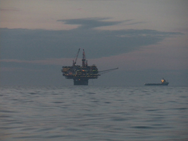 Early that night, around 11 PM, we passed through a part of the UK's offshore oil and gas field. Eight huge, brightly lit, multi storied platforms. Some belching flame and smoke, and in the water off each was a 200ft. patrol safety ship that pointedly came up to our course and, without a word, firmly indicated that we were not to get any closer to their platform. Early morning brought the promised NE wind and we had a great beautiful beam reach for the last fifty miles to Holmengraa Light marking an easy entry through the outer islands. It took a bit of hunting to find an anchorage with enough swinging room and a reasonable depth. Finally, at 6p.m. we dropped anchor in 80 feet in what felt like good mud and after a good G&T and a quick supper, fell into our bunks. Early that night, around 11 PM, we passed through a part of the UK's offshore oil and gas field. Eight huge, brightly lit, multi storied platforms. Some belching flame and smoke, and in the water off each was a 200ft. patrol safety ship that pointedly came up to our course and, without a word, firmly indicated that we were not to get any closer to their platform. Early morning brought the promised NE wind and we had a great beautiful beam reach for the last fifty miles to Holmengraa Light marking an easy entry through the outer islands. It took a bit of hunting to find an anchorage with enough swinging room and a reasonable depth. Finally, at 6p.m. we dropped anchor in 80 feet in what felt like good mud and after a good G&T and a quick supper, fell into our bunks.
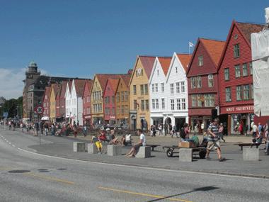 The next day brought warm sun and a light following NE wind to give a lovely easy sail twenty miles down to Bergen where we rafted three out in the inner harbour right in the middle of beautiful Bergen. On the road opposite is a row of three storey brightly painted wooden houses built in the 1700's. Tourists are thick on the ground. When we arrived there were four cruise ships in the outer harbour disgorging their thousands of passengers.
The main street of Bergen is about 50 yards wide, no cars allowed, musicians and art displays encouraged. Lots of fancy shops to look at, but no expectation of buying. Norway is expensive, even for Europeans. A beer and a glass of cider cost $20 CDN. At the head of the harbour is the local market selling fruit, vegetables and souvenirs as well as a huge variety of fish and shellfish. Yes, we bought a generous piece of gravlaks (at huge expense) for our first night's supper, along with reindeer salami and fresh local strawberries....that blew our weekly food budget, but what a treat.
Coming south from Bergen we had a choice of numerous possible routes amongst the myriad of islands and skerries. It would be easy to get lost without a computer mapping program linked to the GPS. Each night we found a perfect anchorage usually in a pool created by a group of islands. Several were in public parks that included tie off points on the rocks, or docks, along with park benches and hiking trails. Norwegian's don't seem to like anchoring. They prefer to drop a stern anchor, run a line ashore and haul the bow to the rocks and jump ashore. It is a learned art and not for Taonui with her high bow and 'senior' crew!
At the end of all these waterways is Stavanger after which all south-bound traffic must go offshore to reach the southern tip of Norway. This stretch of the coast can be treacherous and has a reputation for strong winds and currents. But there are several places where a yacht can run in and shelter behind islands. Korshavn is one such shelter. The entrance from the south or west, as we came, is a twisting and turning channel amongst smooth weather-beaten islands and underwater rocks marked by stakes with top markers of arrows pointing to the right side on which to pass.
Stavanger is the third largest city in Norway. It was once a major fishing port and Hanseatic trading centre with strong links to the Shetland's and Orkney's which were once part of Norway. Today Stavanger is the service centre for Norway's offshore oil and gas extraction industry. The coastline leading into Stavanger is lined with warehouses and factories fabricating strange looking steel shapes for the drilling rigs and huge docks for the fleet of 250 foot long strange looking service vessels that shuttle parts and equipment to the rigs and act as safety patrol around the rigs. Norway is cognisant of the moral conflict between it's oil based wealth and threat posed by carbon emissions. Norway is the world's largest contributor to campaigns to promote re-afforestation throughout the world.
Stavanger is also a great tourist attraction, especially for cruise ships. On each of the three days that we were there were two HUGE 2,500 - 3,000 passenger monsters on the docks at each side of the narrow harbour. They only stay one night, but each day around five thousand tourists hit the town to wonder through the narrow winding hilly streets where the old wooden buildings have been converted to swanky shops and eateries. The Cathedral is well worth visiting. The old part of the Cathedral is similar in style to the one in Lerwick with massive stone Gothic columns. It sits on a hill looking over a wide public square that runs down into the harbour. For us the best part of the square was the fish market and each night we went back to the boat with lovely fresh shrimp, salmon or cod. As an aside note, the cod fishery in the Lofoten Islands in northern Norway is recording record catches. Seems that the warming of the oceans is having some beneficial effects somewhere.
On July 22 we turned around and headed back west along the south coast of Norway. We had gone as far east as Arendal where our mission was to fill our North American propane bottles.
For the next week we wended our way eastward through the inner passages of the offshore islands. These intricate waterways are the summer playground for many Norwegians. There are big and small summer cottages everywhere and everyone, adults and children, has a boat, a power boat ranging from 30-35 foot sleek machines (think, James Bond) to high speed dinghies and ribs with what is often an outsized outboard. And they love to roar around, sometimes just for the hell of it. For us slow pokes, often struggling to figure out which route to take amongst the skerries, it can be a bit unnerving. That said we found some perfect sheltered anchorages in the outer islands often in island clusters that had been set aside as public parks. One, with the typically unpronounceable Norwegian name of Aalesolya, stands out. The entrance to the inner pool was via a circular passage that wound around the inner ring of islands, over several only seven foot deep bars (we draw 6.5 feet), and finally into a two hundred yard wide pool with a sand bottom. Bliss! We spent three days there and had some lovely hikes over the low, lightly wooded, often smooth rocked islands, or rowing quietly through the narrow passages out to the Lighthouse on the eastern edge.
We sailed back west as far as the bustling city of Kristansand, the fifth largest in Norway, and a lovely place to wander around admiring the old wooden houses and churches. It is the tourist centre of the South and every day there are one or more gigantic cruise ships in the harbour. Kristiansand is a natural stopping place for foreign yachts and the city has built a marina in the centre of the town just for visitors. Like everything in Norway, the marina and facilities are of a high standard but expensive.
By August 1 we were back in Scotland at Inverness after an easy 400 miles passage across the North Sea. From there we spent ten days transiting the Caledonian Canal to Oban. It can be done in three days, but the outer sea lock at Corpach, Fort William, had to be closed for repair for five days while we were in the canal. We didn't mind at all. The trip was a pleasure. Slowly motoring down the man-made sections past fields and hills with the banks covered in a profusion of wild flowers. The Canal is sixty miles long, 22 miles dug by hand and the other 38 miles made up of natural bodies of water (Lochs) created by a split in tectonic plates and later carving and scouring during the ice ages. The next day brought warm sun and a light following NE wind to give a lovely easy sail twenty miles down to Bergen where we rafted three out in the inner harbour right in the middle of beautiful Bergen. On the road opposite is a row of three storey brightly painted wooden houses built in the 1700's. Tourists are thick on the ground. When we arrived there were four cruise ships in the outer harbour disgorging their thousands of passengers.
The main street of Bergen is about 50 yards wide, no cars allowed, musicians and art displays encouraged. Lots of fancy shops to look at, but no expectation of buying. Norway is expensive, even for Europeans. A beer and a glass of cider cost $20 CDN. At the head of the harbour is the local market selling fruit, vegetables and souvenirs as well as a huge variety of fish and shellfish. Yes, we bought a generous piece of gravlaks (at huge expense) for our first night's supper, along with reindeer salami and fresh local strawberries....that blew our weekly food budget, but what a treat.
Coming south from Bergen we had a choice of numerous possible routes amongst the myriad of islands and skerries. It would be easy to get lost without a computer mapping program linked to the GPS. Each night we found a perfect anchorage usually in a pool created by a group of islands. Several were in public parks that included tie off points on the rocks, or docks, along with park benches and hiking trails. Norwegian's don't seem to like anchoring. They prefer to drop a stern anchor, run a line ashore and haul the bow to the rocks and jump ashore. It is a learned art and not for Taonui with her high bow and 'senior' crew!
At the end of all these waterways is Stavanger after which all south-bound traffic must go offshore to reach the southern tip of Norway. This stretch of the coast can be treacherous and has a reputation for strong winds and currents. But there are several places where a yacht can run in and shelter behind islands. Korshavn is one such shelter. The entrance from the south or west, as we came, is a twisting and turning channel amongst smooth weather-beaten islands and underwater rocks marked by stakes with top markers of arrows pointing to the right side on which to pass.
Stavanger is the third largest city in Norway. It was once a major fishing port and Hanseatic trading centre with strong links to the Shetland's and Orkney's which were once part of Norway. Today Stavanger is the service centre for Norway's offshore oil and gas extraction industry. The coastline leading into Stavanger is lined with warehouses and factories fabricating strange looking steel shapes for the drilling rigs and huge docks for the fleet of 250 foot long strange looking service vessels that shuttle parts and equipment to the rigs and act as safety patrol around the rigs. Norway is cognisant of the moral conflict between it's oil based wealth and threat posed by carbon emissions. Norway is the world's largest contributor to campaigns to promote re-afforestation throughout the world.
Stavanger is also a great tourist attraction, especially for cruise ships. On each of the three days that we were there were two HUGE 2,500 - 3,000 passenger monsters on the docks at each side of the narrow harbour. They only stay one night, but each day around five thousand tourists hit the town to wonder through the narrow winding hilly streets where the old wooden buildings have been converted to swanky shops and eateries. The Cathedral is well worth visiting. The old part of the Cathedral is similar in style to the one in Lerwick with massive stone Gothic columns. It sits on a hill looking over a wide public square that runs down into the harbour. For us the best part of the square was the fish market and each night we went back to the boat with lovely fresh shrimp, salmon or cod. As an aside note, the cod fishery in the Lofoten Islands in northern Norway is recording record catches. Seems that the warming of the oceans is having some beneficial effects somewhere.
On July 22 we turned around and headed back west along the south coast of Norway. We had gone as far east as Arendal where our mission was to fill our North American propane bottles.
For the next week we wended our way eastward through the inner passages of the offshore islands. These intricate waterways are the summer playground for many Norwegians. There are big and small summer cottages everywhere and everyone, adults and children, has a boat, a power boat ranging from 30-35 foot sleek machines (think, James Bond) to high speed dinghies and ribs with what is often an outsized outboard. And they love to roar around, sometimes just for the hell of it. For us slow pokes, often struggling to figure out which route to take amongst the skerries, it can be a bit unnerving. That said we found some perfect sheltered anchorages in the outer islands often in island clusters that had been set aside as public parks. One, with the typically unpronounceable Norwegian name of Aalesolya, stands out. The entrance to the inner pool was via a circular passage that wound around the inner ring of islands, over several only seven foot deep bars (we draw 6.5 feet), and finally into a two hundred yard wide pool with a sand bottom. Bliss! We spent three days there and had some lovely hikes over the low, lightly wooded, often smooth rocked islands, or rowing quietly through the narrow passages out to the Lighthouse on the eastern edge.
We sailed back west as far as the bustling city of Kristansand, the fifth largest in Norway, and a lovely place to wander around admiring the old wooden houses and churches. It is the tourist centre of the South and every day there are one or more gigantic cruise ships in the harbour. Kristiansand is a natural stopping place for foreign yachts and the city has built a marina in the centre of the town just for visitors. Like everything in Norway, the marina and facilities are of a high standard but expensive.
By August 1 we were back in Scotland at Inverness after an easy 400 miles passage across the North Sea. From there we spent ten days transiting the Caledonian Canal to Oban. It can be done in three days, but the outer sea lock at Corpach, Fort William, had to be closed for repair for five days while we were in the canal. We didn't mind at all. The trip was a pleasure. Slowly motoring down the man-made sections past fields and hills with the banks covered in a profusion of wild flowers. The Canal is sixty miles long, 22 miles dug by hand and the other 38 miles made up of natural bodies of water (Lochs) created by a split in tectonic plates and later carving and scouring during the ice ages.
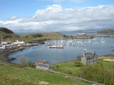 We arrived back in Oban in lovely warm late summer weather. After three days of the usual shopping, laundry etc. and some end of season boat maintenance we set off for a leisurely trip up the Sound of Mull to Tobermory where Coryn left by bus to Craigmuir, ferry to Oban, local train to Glasgow, overnight train to London with plans to visit brother in Cambridge and various nephews on Saturday and then fly back to Victoria.
Scotland to Azores
On August 30 I left Tobermory at 11:00 and by 17:00 was clear of the south end of Tiree with open ocean ahead for the next 1,330 miles to Terceira, in the Azores. Easy sailing in 15 knots of NW wind that slowly veered into the west and forecast to go to SW and increase to 25+ knots as a ridge of high pressure moves east across the UK and a low fills in behind it. This is the first high that I could remember this summer. Mostly it has been one low after another. I expected that it would be hard sailing until I could get south of 50N and out of the steady stream of lows.
It was tough hard on the wind slogging for the next three days as I fought to get past the NW point of Ireland and then away from the west coast of Ireland. All the time the wind blew SW. Three reefs in the main and the staysail with Albert (Monitor self-steering) doing sterling work. The September 3 noon Shipping Forecast called for a 987 low SE of Iceland, Storm Force 11 in Bailey. I kept jogging along waiting for the wind to shift and by noon on September 4 the wind had gone all the way around into the north and Taonui was sailing free and logged 140 miles for the next 24 hours. The easy sailing stayed for three days. On the evening of September 7 I wrote this in the log:
I hope that I can remember this evening. Wind just ahead of the mast, one reef and #1 genoas. Making 6 6.3 knots. Taonui moving easily. Occasional dollop of spray on the foredeck. Albert steering, all is quiet save for the swash, shwiss as she caresses each wave and pushes it aside. Odd clunk from Albert. Swoosh, or is Hush and underlying that, the whisper of a long stream of bubbles along the hull. The wake stretches back 20 30 yards and then is gone. High overcast...south side of the High. Peace. What else could I want to feel. It will be a lovely night's sleep. Wind shift in the morning. Back to close hauled. Great boat. Thanks. So lucky
In the next three days two lows passed to the north giving head winds with some relief between fronts. By September 11 I was south of a high pressure ridge and made 161 miles noon-to-noon in strong 30 - 35 NNE and NE winds. It was a relief to finally get into the shelter of the outer breakwater at Praia de Vitoria on Terceria Island in the late morning of September 12. 1,384 miles at an average of 106 miles a day. Not bad, considering the prevailing head winds. We arrived back in Oban in lovely warm late summer weather. After three days of the usual shopping, laundry etc. and some end of season boat maintenance we set off for a leisurely trip up the Sound of Mull to Tobermory where Coryn left by bus to Craigmuir, ferry to Oban, local train to Glasgow, overnight train to London with plans to visit brother in Cambridge and various nephews on Saturday and then fly back to Victoria.
Scotland to Azores
On August 30 I left Tobermory at 11:00 and by 17:00 was clear of the south end of Tiree with open ocean ahead for the next 1,330 miles to Terceira, in the Azores. Easy sailing in 15 knots of NW wind that slowly veered into the west and forecast to go to SW and increase to 25+ knots as a ridge of high pressure moves east across the UK and a low fills in behind it. This is the first high that I could remember this summer. Mostly it has been one low after another. I expected that it would be hard sailing until I could get south of 50N and out of the steady stream of lows.
It was tough hard on the wind slogging for the next three days as I fought to get past the NW point of Ireland and then away from the west coast of Ireland. All the time the wind blew SW. Three reefs in the main and the staysail with Albert (Monitor self-steering) doing sterling work. The September 3 noon Shipping Forecast called for a 987 low SE of Iceland, Storm Force 11 in Bailey. I kept jogging along waiting for the wind to shift and by noon on September 4 the wind had gone all the way around into the north and Taonui was sailing free and logged 140 miles for the next 24 hours. The easy sailing stayed for three days. On the evening of September 7 I wrote this in the log:
I hope that I can remember this evening. Wind just ahead of the mast, one reef and #1 genoas. Making 6 6.3 knots. Taonui moving easily. Occasional dollop of spray on the foredeck. Albert steering, all is quiet save for the swash, shwiss as she caresses each wave and pushes it aside. Odd clunk from Albert. Swoosh, or is Hush and underlying that, the whisper of a long stream of bubbles along the hull. The wake stretches back 20 30 yards and then is gone. High overcast...south side of the High. Peace. What else could I want to feel. It will be a lovely night's sleep. Wind shift in the morning. Back to close hauled. Great boat. Thanks. So lucky
In the next three days two lows passed to the north giving head winds with some relief between fronts. By September 11 I was south of a high pressure ridge and made 161 miles noon-to-noon in strong 30 - 35 NNE and NE winds. It was a relief to finally get into the shelter of the outer breakwater at Praia de Vitoria on Terceria Island in the late morning of September 12. 1,384 miles at an average of 106 miles a day. Not bad, considering the prevailing head winds.
2013 Azores to Lymington
I returned to Terceira in early May, 2013 and spent two weeks getting Taonui ready. Three coats of anti-fouling, varnished all the floor boards, stripped all the winches. She was ready to go. During the winter we had agreed to sell Taonui to Anne and Glen Bainbridge from Bracebridge, Ontario who were looking for a boat to take them to the high latitudes. The sale was subject to a survey to be carried out in Lymington. This gave me one last ocean passage.
I left on May 18 with a forecast of head winds for at least a week. It was a rough passage, tacking against the NE wind, hunting for wind shifts. After seven days the wind went light for 24 hours and then built in from the west. The last two days were a lovely wing and wing sail with two reefs and 3/4 of the inner genoa, cracking off 150 miles a day. A wonderful way to end the trip. 1,300 miles in 10 days.
Coryn joined me in Falmouth for the last leg along the south coast of England to Lymington. As luck would have it, we had strong head winds the whole way. Taonui was hauled out at the Berthon Yard where she had spent many winters. The survey was rigorous, as it should be, including a detailed ultrasound examination of each square foot of the hull. Taonui passed with flying colours.
After 110,000 miles of ocean sailing and 17 years of adventures we were sad to say goodbye, but were happy to know that she would continue to wander the seas. A true bird of the open oceans and the wonderful wilderness of the high latitudes.
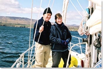
Fair winds and smooth seas

|
|